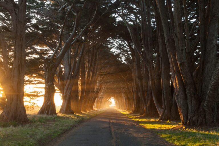
A Complete Guide to the Best West Coast National Parks
The West Coast of the United States is home to some of the most incredible national parks in the entire country. From the rocky peaks and alpine lakes of the national parks in Washington, to the deserts in southern California, you’ll find an incredible diversity of landscapes throughout Washington State, Oregon, and California’s national parks.
We’ve lived on the West Coast for our entire lives, and have explored every single west coast national park together over the past several years. We put together this guide to help give you the information and resources you need to explore them for yourself.
Note: By “West Coast,” we mean Washington State, California, and Oregon. We’re not including Alaska because we’ve never been (though we DEFINITELY want to!). We’ve been all over places like Arizona, Utah, Nevada, and Idaho, but we’re not including them here because they’re not on the West Coast!
Disclaimer: Some of the links in this post, like hotel and vacation rental links, are affiliate links, meaning at no additional cost to you we make a little bit of money if you click through and book. That being said, we would absolutely never recommend something to you that we don’t stand behind 100%.
A Guide to Visiting all 13 West Coast National Parks
Now let’s get into exactly what to do, when to go, and where to stay to visit each national park.
At the time of writing, we’ve visited 13 national parks in the past year. We’ve basically done one big road trip, circling from Washington and Oregon, down to California, and over to Utah, Wyoming, Arizona, and Colorado.
Here, you’re only going to find those in Washington, Oregon, and California.
If you want to learn about other national parks in the American West, head over to our other site, Wheatless Wanderlust, and read our guides to Yellowstone, the Grand Canyon, and Utah’s National Parks (including Bryce and Zion).
National Parks in Washington
There are three national parks in Washington, and all three bring a different landscape to the table (or, in the case of Olympic National Park, three landscapes in one!).
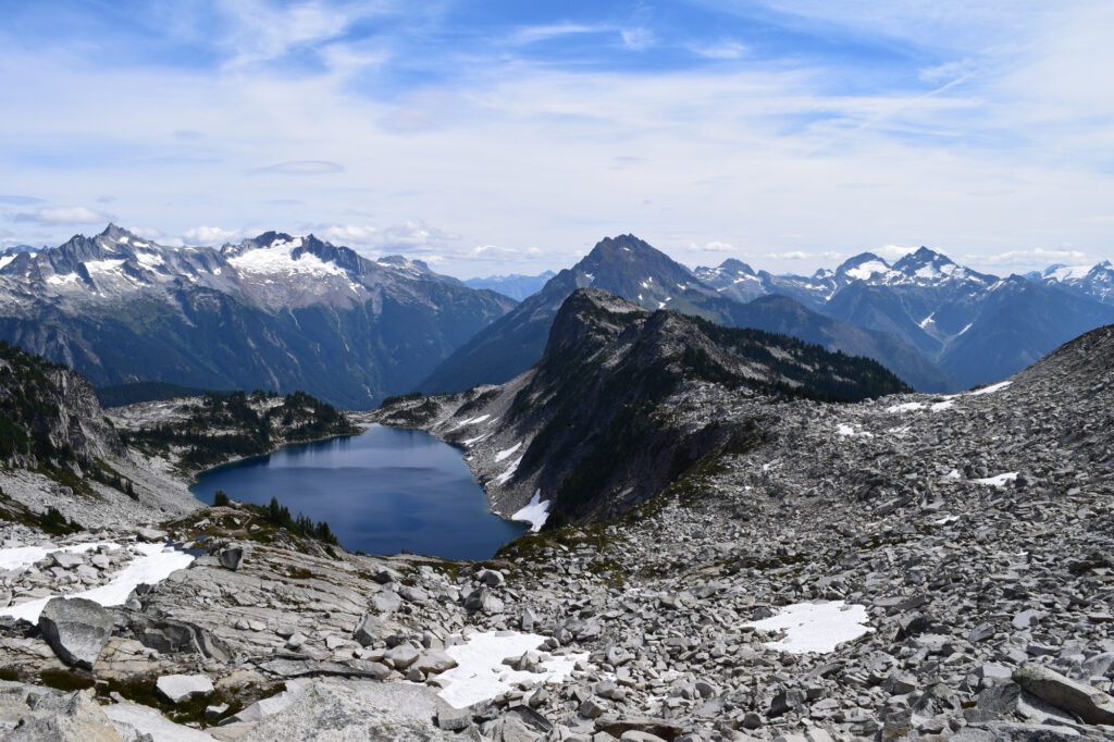
North Cascades National Park
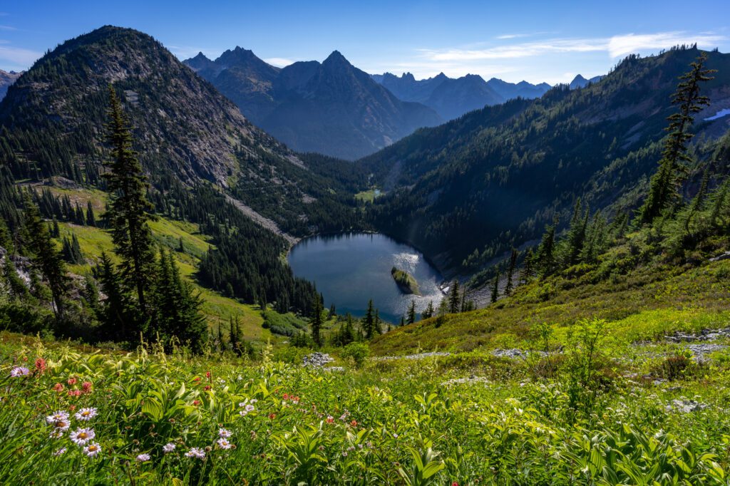
We love the North Cascades.
It’s the least-visited national park in Washington, but it’s arguably just as spectacular as Mt. Rainier and Olympic. It’s also free to enter, which is a major plus.
The rocky peaks and alpine lakes sprinkled throughout the North Cascades are a hiker’s dream. Whether you’re looking for an easy day hike or a multi-day adventure, there’s a great hike in the North Cascades waiting for you.
Go For: World-class hiking.
When to Visit: You’re going to be in the mountains, which means hiking trails are covered in snow until about mid-July most years. Visit from mid-July through September for the best hiking conditions. Fall color in early to mid-October is spectacular, but conditions will be more variable with a higher chance of rain or snow.
Getting There: Head up I-5 from Seattle, turning off onto Hwy 20, which takes you all the way through the Cascades and into eastern Washington.
Park Highlights:
- The Maple Pass loop is our favorite hike in Washington State.
- The Blue Lake Trail is a good, easier hike to a gorgeous alpine lake.
- Drive the entirety of the North Cascades Highway, stopping at blue-green Diablo Lake and the scenic overlook at Washington Pass, and ending in the charming town of Winthrop in the foothills of the Cascades.
- Get out on Ross Lake by renting a canoe or Kayak from Ross Lake Resort.
Where to Stay: Inside the park, camping is your only option. Camp at Colonial Creek or Newhalem Campground (we prefer the first). Make reservations six months in advance, if you can – they’re super competitive. We like staying in Winthrop, which is a great home base for exploring the park (and is a cool place to explore in its own right).
More Information:
- How to Plan a Perfect North Cascades Itinerary
- The Best Hikes in the North Cascades
- Current Conditions (NPS)
- Camping in the Park (NPS)
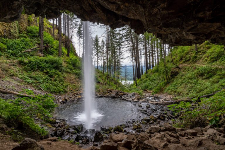
Olympic National Park
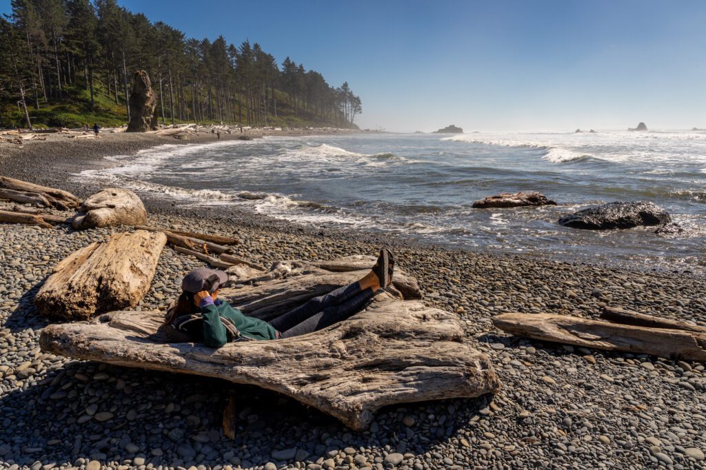
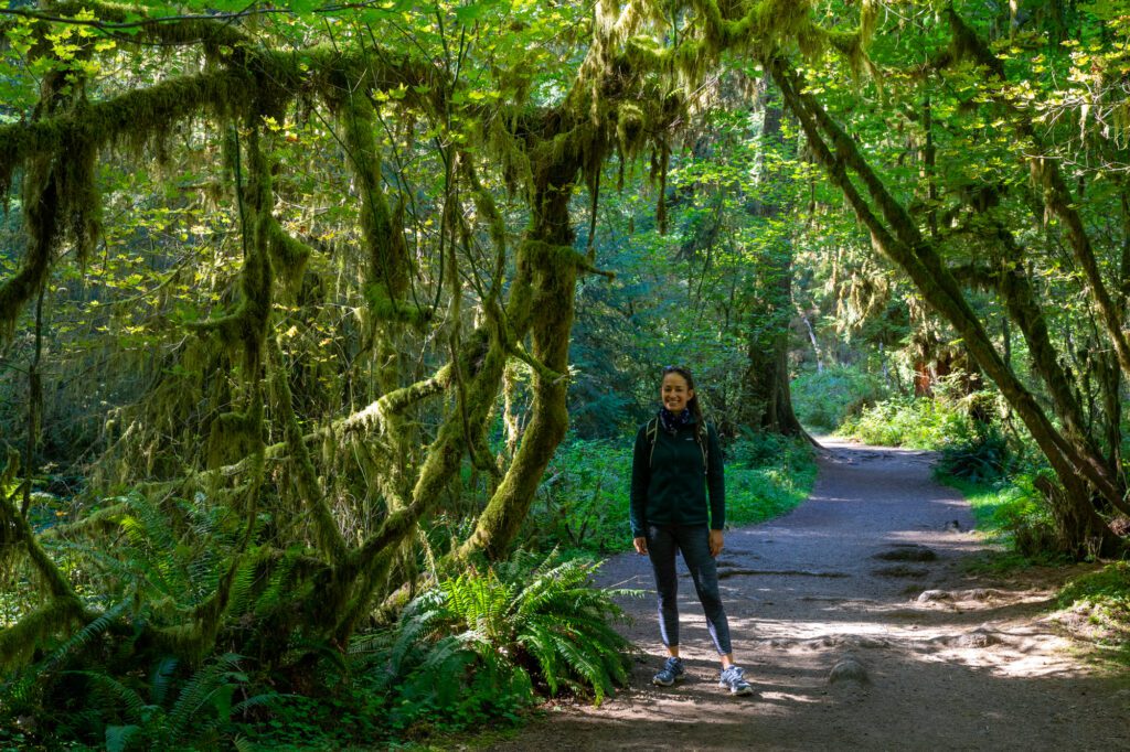
Olympic National Park is one of the most interesting national parks in the country thanks to the plethora of different ecosystems that exist within the park. Within the boundaries of the park, which are confusing because they start and stop at odd points, you’ll find an alpine section that looks straight out of the alps with rocky peaks and alpine lakes, a coastal section with rugged, rocky beaches and amazingly photogenic sea stacks, and the temperate rainforest, which is a unique feature of the Pacific Northwest.
Go For: The temperate rainforest and rugged Pacific Coast.
When to Visit: The park is accessible year round since it’s not at high elevation, but summer brings warm sunny days and far less rain.
Getting There: Take the Bainbridge Island Ferry from Seattle and drive to Port Angeles and Forks, or drive up I-5 from Portland, approaching from the south and starting at Lake Quinault.
Park Highlights:
- Explore the park’s stunning range of different biomes from alpine to coastal to rainforest.
- Hike around Hurricane Ridge – home to the park’s best hikes like Hurricane Hill and Klahhane Ridge.
- Stop at Lake Crescent to hike to Marymere Falls (more adventurous travelers should continue up to Mount Storm King).
- Hit all the beaches on the Pacific Coast, but mostly Shi Shi, Rialto (and hike to Hole in the Wall), and Ruby.
- Experience the tranquility of the Hoh Rainforest, particularly at dawn before the crowds ruin the ambiance.
Where to Stay: Olympic National Park is a big park and that means you’re likely going to need to split your time to avoid driving extra hours. We’d recommend a night or two around Port Angeles (or a vacation rental on Lake Sutherland) to do Hurricane Ridge and Lake Crescent, and a night or two in Forks to explore the coastal areas.
More Information:
- How to Plan the Perfect Olympic National Park Itinerary
- The Best Hikes in Olympic National Park
- Where to Stay in Olympic National Park
- Hiking the Enchanted Valley Trail in Olympic National Park
- Current Conditions (NPS)
- Camping in the Park (NPS)
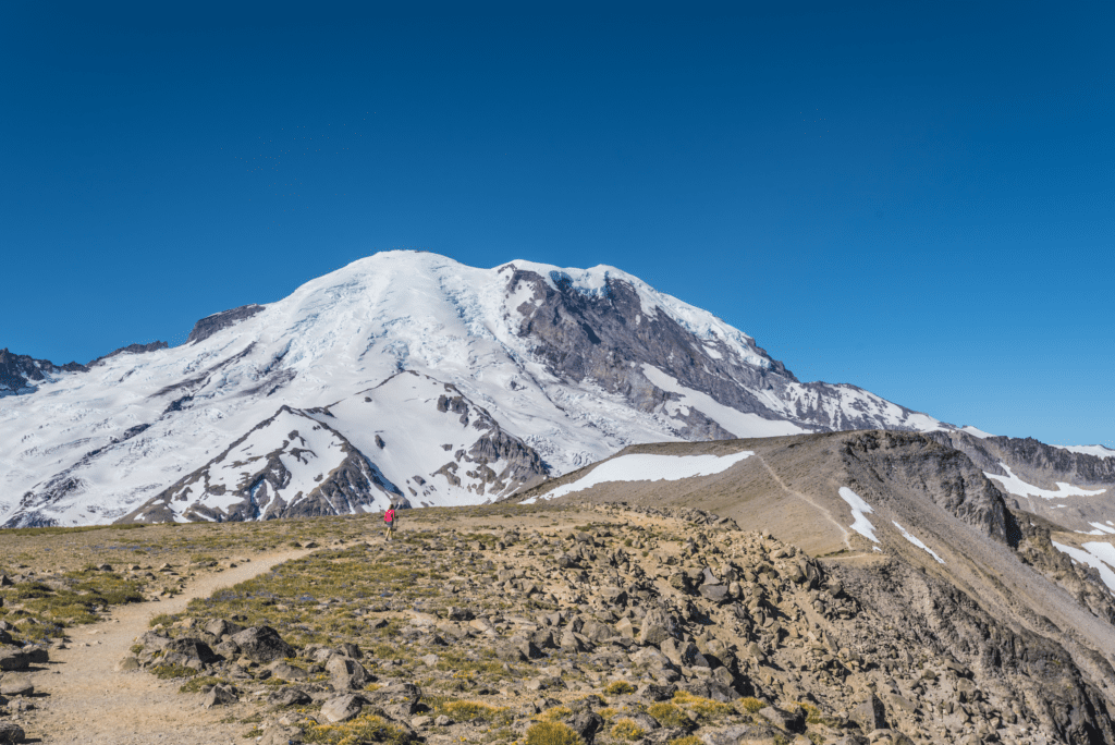
Mt. Rainier National Park
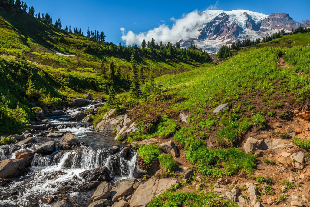
Ah, Mt. Rainier. The peak that is visible on a sunny day from pretty much anywhere in the state of Washington. It’s plenty impressive from Kerry Park in Seattle, but it’s even more magnificent once you get up close and personal. There are multiple regions of the park (read about them here), but our two favorites are Paradise and Sunrise.
Go For: Amazing hiking around the tallest peak in Washington State.
When to Visit: Summer (July) to early fall (through September) is best if you like hiking. The only part of the park that’s open in the winter and spring is Paradise, and it’ll be a winter wonderland of snow-covered meadows and frozen ponds. The road to Sunrise, the highest point you can drive to in the park, closes from October to June, depending on the year.
Getting There: To get to Paradise, you’ll take I-5 north or south (from Portland or from Seattle) to Hwy 7, then take 706 east into the park. To get to Sunrise, take 169 S from Seattle to Enumclaw, where you’ll connect with 410 that takes you into the park.
Park Highlights:
- Paradise: The most-visited part of the park, the highlights here are the Skyline Trail, Reflection Lakes, and all the waterfalls (Myrtle, Narada, Comet, and Christine).
- Sunrise: Home to the highest concentration of amazing hikes at Mt. Rainier, you’ll want to hit the Summerland Trail, the Mt. Fremont Lookout Trail, and the Burroughs. In early summer, head to Berkeley Park for a stunning display of blankets of multi-colored wildflowers.
Where to Stay: For Paradise, camp at Cougar Rock or stay in the town of Ashford – Paradise Village or a vacation rental are your best bets.
More Information:
- The Best Things to Do at Mt. Rainier National Park
- Complete Guide to Hiking at Mt. Rainier
- How to Plan a Perfect Day at Mount Rainier
- Hiking the Naches Peak Trail: Best Bang-for-your-buck at Rainier
- Hiking the Burroughs Mountain Trail in Mount Rainier National Park
- Current Conditions (NPS)
- Camping in the Park (NPS)
National Parks in Oregon
Spoiler alert: there’s only one! But Oregon is one of our favorite places in the entire world, and we definitely support planning an Oregon road trip or a weekend in Portland to dip your toes in the water.
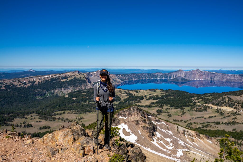
Crater Lake National Park
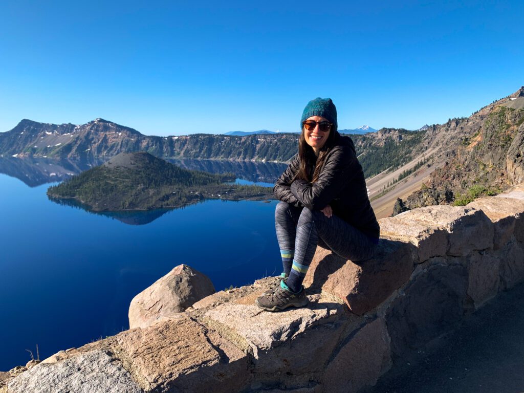
Yes, the water at Crater Lake National Park IS that blue. Especially midday when the sun is high in the sky.
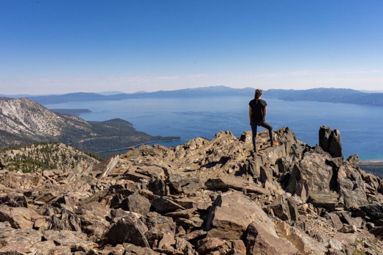
Crater Lake, which used to be a huge volcano before it collapsed thousands of years ago, is a sight worth seeing. It’s the deepest lake in the United States at over 2,000 feet deep. Like Lake Tahoe, the water is crystal clear, which gives it that rich sapphire blue color.
Go For: The deepest lake in the United States, the sapphire colored water, and the panoramic views over the surrounding area of southern Oregon and northern California.
When to Visit: It’s going to be best from mid-June through the fall, when you’ll be able to drive the entirety of the road along the rim of the lake. Other times of year, you’ll be able to drive to the Visitor Center on the southern end of the crater, but that’s basically it (and road closures make it hard to get there).
Getting There: Crater Lake is one of the least convenient parks to get to from a major city. From Portland, it’s a five hour drive on a good day. From San Francisco, it’s just under seven hours. It’s best done as part of a road trip between Oregon and California, and even then it’s going to be a little bit out of the way.
Park Highlights:
- If you’re able, you absolutely should hike to the highest and lowest accessible points in the park – the peak of Mount Scott, where you’ll have views across the lake all the way to Mt. Shasta in California, and Cleetwood Cove, where you can hike all the way down to the water level.
- Drive the Crater Rim. All of it. And try to do it either before 9am or after 6pm, when you’ll have the best light AND the fewest people jockeying for parking at the pullouts.
- Catch the sunset at Garfield Peak, which is a short, steep hike near Crater Lake Lodge with panoramic views over the lake. You’ll see the sun to your left, and the rim of the lake lighting up with all sorts of golden hues as that sun dips below the horizon.
Where to Stay: Crater Lake really doesn’t have too many convenient options outside the park, so this is a place where staying inside the park will help you A LOT. Camp at Mazama Campground or splurge for a night at the Crater Lake Lodge. Outside the park, Fort Klamath is your best bet. It’s just over a half an hour away from the main Visitor Center in the park. Check out the Crater Lake Resort, where you can choose between lodge rooms, cabins, and glamping tents, or choose a vacation rental nearby.
More Information:
National Parks in California
The vast majority of west coast national parks are located in the golden state. The nine national parks across California offer incredibly diverse landscapes and experiences. From the boulders of Joshua Tree to the valleys of Yosemite to the sea caves of the Channel Islands, there is so much natural beauty to see across the state.
I’m a California native, and I’ve spent a fair share of time in my home state’s beautiful national parks. Here is a look at what to expect in each of California’s parks!
Author Note: This section on California was written by Kyra Heenan, our resident California native whose home base is in southern California, but she has explored all over the golden state.
Redwood National and State Parks

RNSP is a unique system consisting of four parks (Redwood National Park and Del Norte Coast, Jedediah Smith, and Prairie Creek Redwoods State Parks). Beyond walking amidst the breathtaking, centuries-old trees (which are among the tallest in the world), there are also opportunities to explore the beautiful Northern California coast.
Go For: It’s in the name: the impressive old-growth redwood trees!
When to Visit: The best time to visit is in the summer and early fall. The comparatively warmer weather and lack of rainfall make this the ideal time to explore the park. Keep in mind that it can still be cool, particularly at night and closer to the coast.
Getting There: The parks all line the 101 highway, which travels north-south. To access Redwood National Park from the south, travel on the 101 North and turn right on Bald Hills Road, past Orick. From the north, travel down the 101 South and turn left on Bald Hills Road, past Berry Glen. Note that unlike many other parks, there is no formal entrance station in the park.
Park Highlights:
- Hike amongst the famous redwood trees at Tall Trees Grove Loop Trail (3.3 miles), Lady Bird Johnson Grove Trail (1.3 miles), and Trillium Falls Trail (2.6 miles).
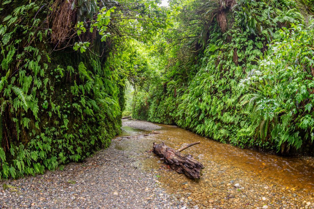
- Head to Prairie Creek Redwoods State Park to hike Fern Canyon Loop Trail (1.1 miles), a creekside canyon hike that leads to a waterfall.
- Drive along Newton B. Drury Scenic Parkway, a 10-mile road that cuts through Prairie Creek Redwoods State Park. You’ll pass by old-growth redwood forests, and will likely see some Roosevelt elk out your car window.
- Drive north to Del Norte Coast Redwoods State Park to enjoy a coastal hike at Last Chance California Coastal Trail (1.4 miles).
Where to Stay: The charming coastal town of Trinidad has the best options when it comes to hotels and motels, but you’ll find accommodations at most of the coastal towns that border these parks. We like Emerald Forest Cabins and the View Crest Lodge in Trinidad. If you want to camp, there are four developed campgrounds within the park system, which can be reserved online. Mill Creek Campground (in Del Norte Coast) is tucked away from the highway in a heavily wooded area, and is great if you’re looking for an option further north. Elk Prairie Campground (in Prairie Creek, just north of Redwood National Park) is located off Newton B. Drury Scenic Parkway, and is conveniently located near many great trails.
More Information:
- Developed Campgrounds (NPS)
- Backcountry Camping and Permits (NPS)
- Current Conditions (NPS)
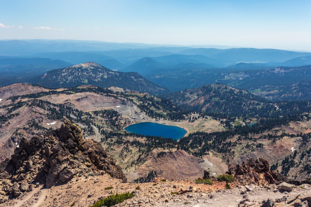
Lassen Volcanic National Park
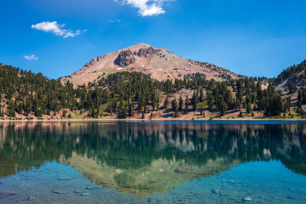
While Lassen may not be as popular as some other California national parks, it offers an incredibly unique experience. This northern California national park features all four types of volcanoes, and trails with views of lakes, lush meadows, and hydrothermal areas.
Go For: The experience of getting up close to hydrothermal areas, which show signs of volcanic activity.
When to Visit: The best time to visit is during the summer and early fall. The Lassen Peak Highway (the 89) is closed in the winter, which means access to the park is limited. Since the highway road snow clearing can go into the late spring, check the road conditions before planning a spring visit.
Getting There: From the south, head up the 5 and connect to the 36 in Red Bluff. Continue for about 45 miles and then turn left on the 89, following the highway into the park at the southwest entrance. From the north, head down the 5 and connect to the 44 in Redding. Continue for about 45 miles and then turn right on the 89, following the highway into the park at the northwest entrance.
Park Highlights:
- Check out hydrothermal areas to see boiling mud pots, steam and volcanic gas vents, and other signs of active volcanism. Sulphur Works is the most accessible hydrothermal area, located right off the 89 highway. A popular hike is Bumpass Hell Trail (2.7 miles), which gives you up-close views of the largest hydrothermal area in the park.
- Take in the views of Lassen Volcanic National Park (and get a good workout in!) by hiking Lassen Peak, an out-and-back trail that is just over 5 miles long.
- Enjoy a picnic and take some photos of Lake Helen, which is located right off the 89 (and across the street from the Bumpass Hell Trailhead).
- Hike through some of Lassen’s most iconic trails, including Cinder Cone Nature Trail (4 miles), Kings Creek Falls Trail (2.7 miles), and Manzanita Lake Loop (1.9 miles).
Where to Stay: Hotel options are incredibly limited around the park, so the most convenient options are either renting a vacation rental or camping. The town of Mineral has plenty of home rental options, and is a 15-minute drive from the southwest entrance. If you plan on camping, there are seven campgrounds within the park, and reservations can be made online. For camping, I recommend Manzanita Lake Campground. It is the largest and one of the longest open campgrounds in the park, and has both campsites and cabins available.
More Information:
- Stargazing (NPS)
- Camping (NPS)
- Current Conditions (NPS)
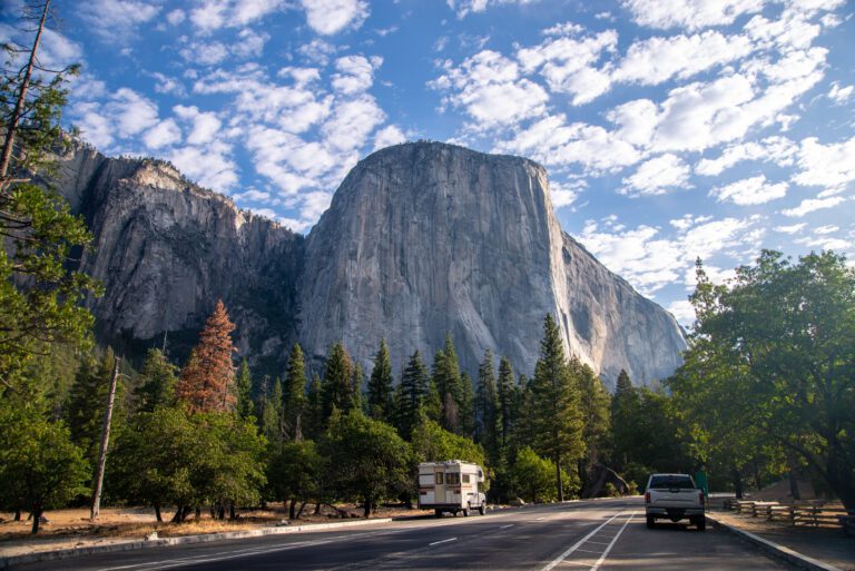
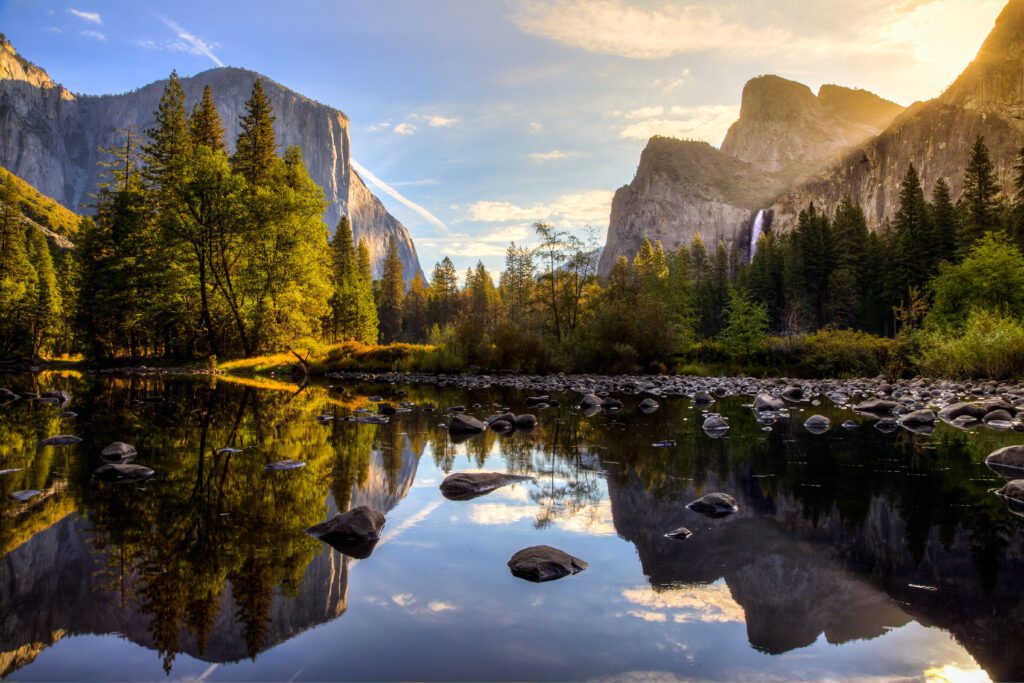
Yosemite National Park
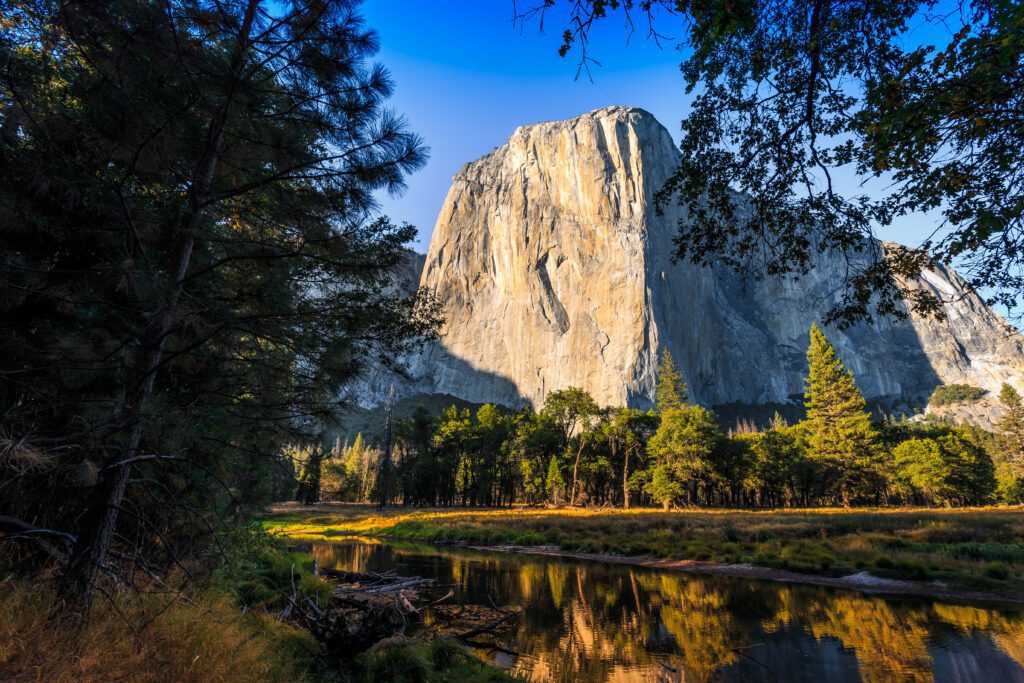
Yosemite is one of the most visited national parks in the US. While the crowds can get big (especially in the summer), it’s definitely worth a visit – this popular national park lives up to the hype! As you hike and drive through the park, you’ll experience impressive cliffs, beautiful waterfalls, giant trees, and more.
Go For: Amazing hiking and some of the best views in the state.
When to Visit: The park is open year-round, although snowy conditions may make it difficult to fully explore the park in the winter. For milder weather and fewer crowds, consider visiting in the spring or fall.
Getting There: From the north, you’ll get to Yosemite via the 120 highway, and connect to Big Oak Flat Road to get into the valley. From the west, you’ll get to Yosemite via the 140 highway, which turns into El Portal Road before entering the valley. From the south, you’ll get there via the 41 highway, which turns into Wawona Road before entering the valley.
Park Highlights:
- Check out the base of Yosemite Falls (and hike to Upper Yosemite Falls if you’re feeling up for it!).
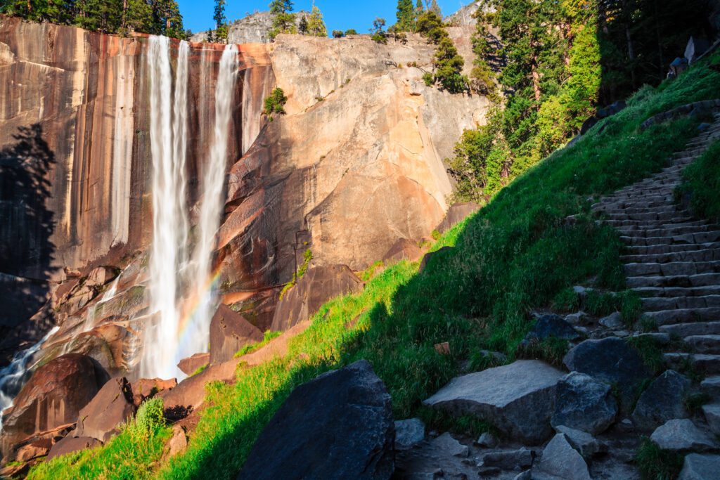
- Hike the Mist Trail to see Vernal Falls, and for a more challenging hike, continue along the trail to see Nevada Falls.
- After a long day of hiking, find a spot on one of the beaches or picnic areas along the Merced River in Yosemite Valley to relax or go for a dip in the water.
- Drive (or hike via the Four Mile Trail) up to Glacier Point for incredible views of Half Dome and the Yosemite Valley.
- Yosemite Valley draws the most visitors, but there’s plenty to see outside of the valley, too. Hike along Hetch Hetchy Reservoir or around Tuolumne Meadows, or look at the giant sequoias at Mariposa Grove.
Where to Stay: Within the park, there are a variety of different lodging options including hotels and tent cabins. Choose the Ahwahnee for a luxurious stay in the best part of the park, or the Yosemite Valley Lodge for a more mid-range experience. There are also 13 campgrounds in the park, and reservations are required for most. Upper and Lower Pines Campgrounds (in the Yosemite Valley) are super conveniently located near many of the most popular sights and trailheads in the park. If you want to be away from the crowds, Tuolumne Meadows Campground is a great option, and is also less competitive (keep in mind that it’s only open from July to September). If you’re looking for a hotel or home rental outside of the park, I recommend El Portal (about a 10-minute drive from the park entrance on the 140 highway).
More Information:
- 2 Days in Yosemite: Planning Your Yosemite National Park Itinerary
- Camping Without a Reservation (NPS)
- Current Conditions (NPS)
Kings Canyon National Park
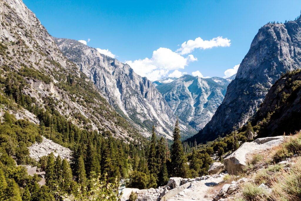
Kings Canyon National Park has a terrain similar to Yosemite, featuring waterfalls, scenic valleys, and gorgeous trees. While it may not get as much attention as Yosemite to the north or Sequoia to the south, it still stands its ground as one of the most beautiful national parks in California.
Go For: The scenic valleys and amazing waterfalls.
When to Visit: The park is open year-round, although some portions may be temporarily closed during the winter due to snow. You’ll get the best weather in the late spring, summer, and early fall.
Getting There: There is one entrance to the park: Big Stump Entrance on the 180 highway. From the north, drive south down the 99 to connect to the 180, and follow it into the park. From the south, drive north up the 99, exiting and turning right in Goshen. Turn left on Road 80, right on Avenue 384, left on Road 120, and then continue until you turn right on the 180, following it into the park.
Park Highlights:
- Enjoy some hikes in the Cedar Grove area of the park, including Mist Falls (8.7 miles) and Zumwalt Meadow Loop (1.6 miles).
- Take a tour of Boyden Cavern, a marble cavern in the middle of the park.
- Check out some of the easily accessible waterfalls in the park, including Grizzly Falls and Roaring River Falls.
- Visit Grant Grove to see the massive General Grant Tree (and other beautiful sequoias).
- Hike amongst the sequoias and get incredible views of Sequoia Lake via Sequoia Lake Overlook (2.8 miles).
- Drive up Panoramic Point and take in the view of the park from above at Kings Canyon Panoramic Point.
Where to Stay:
There are a few lodges within the park, including Grant Grove Cabins, John Muir Lodge, and the Cedar Grove Lodge. Outside of the park, the most convenient options for hotels and home rentals are in the Pinehurst area (under 20-minute drive to the park). There are also campgrounds in both the Cedar Grove and Grant Grove areas, and reservations can be made online. Azalea Campground is one of the most beautiful, located near the largest sequoias in the park.
More Information:
- Current Conditions (NPS)
- Camping (NPS)
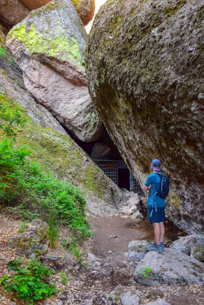
Pinnacles National Park
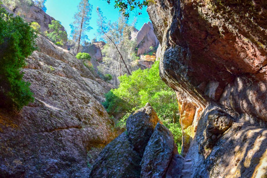
Pinnacles is California’s newest national park, having only gained national park status in 2013. This small park has cool talus caves, tall rock formations, and plenty of trails. There are two entrances to the park, one on the east, one on the west. While they technically aren’t very far from each other, they don’t connect via a drivable road. It’s important to plan your itinerary based on which entrance you plan on staying close to.
Go For: The unique landscape, which was formed by volcanic activity.
When to Visit: Pinnacles is open year-round, although the hot summer weather can be uncomfortable for many. Consider visiting during the spring, fall, or winter for milder weather.
Getting There: To get to the east entrance from the north, drive south down the 101, connecting to the 25 after Gilroy. Continue down the 25, eventually turning right on the 146, which will take you into the park. To get to the west entrance from the north, take the 101 south through Camphora, following signs to connect to the 146. Continue down the road to get to the park.
To get to the east entrance from the south, take the 5 north, exiting on W Jayne Avenue towards Coalinga. Turn left on the 198, following it until you can turn right on the 25. Turn left on the 146, following it into the park. To get to the west entrance from the south, take the 101 north, exiting at S 1st Street in King City. Follow the road, and take a right on the 146, following it into the park.
Park Highlights:
- Enjoy some hiking near the eastern entrance, including the Condor Gulch Trail to High Peaks Trail Loop (5.5 miles), Moses Spring Trail (1.2 miles), and High Peaks Trail (6.4 miles).
- If you’re staying near the western entrance, consider hiking Balconies Cave Trail (2.6 miles), Juniper Canyon Trail (4.5 miles), and Old Pinnacles Trail (9.5 miles).
- Explore the two talus caves in the park, Balconies Cave and Bear Gulch Cave. There are multiple hikes that lead to these caves, depending on which entrance you’re coming from.
Where to Stay: There is one campground in the park (Pinnacles Campground), located on the eastern side. There are tent cabins available, as well as campsites. If you plan on staying outside of the park, there are more hotels located closer to the western entrance. Soledad is the closest town with hotel options (20-minute drive to the entrance), and it’s the best area to stay outside of the park.
More Information:
- Status of the Caves (NPS)
- Trails (NPS)
- Current Conditions (NPS)
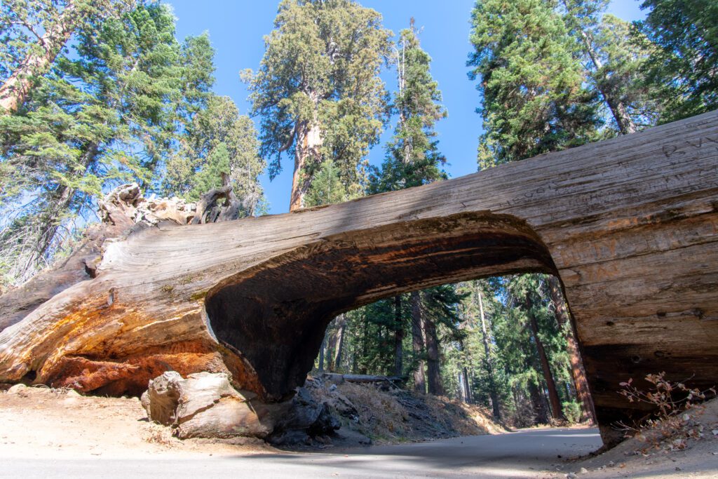
Sequoia National Park
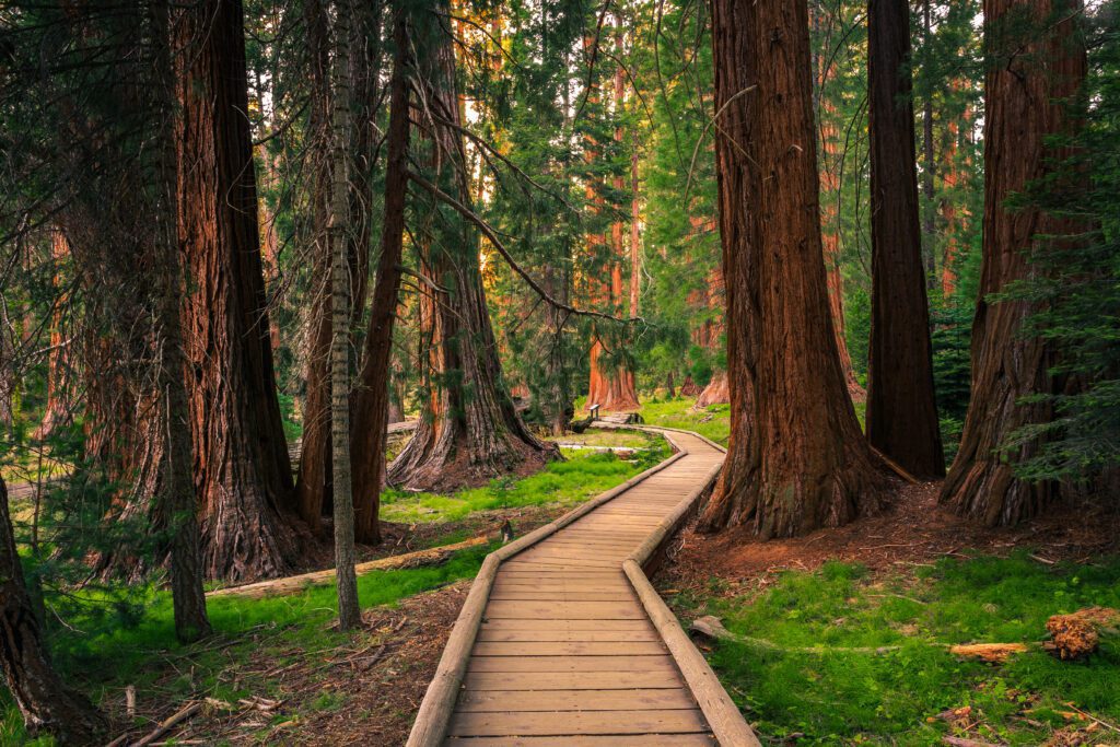
Sequoia – which is contiguous with Kings Canyon, and located just south of it – is known for sweeping vistas, beautiful waterfalls, and (of course) its giant sequoias. The diverse landscape and variety of tralis makes this park a hiker’s dream.
Go For: The iconic sequoia trees.
When to Visit: Sequoia is open year-round, but some roads may close in the winter due to snow. The weather is best in the late spring, summer, and early fall.
Getting There: From the north, take the 5 south to the 198 east, following it into the park. From the south, take the 5 north to the 99, and then the 65. Follow it north until you hit the 198, and turn right, following the highway into the park.
Park Highlights:
- Take the stairs up to the top of Moro Rock for incredible views of the park.
- Check out the 275-foot tall General Sherman Tree, and then hike along Congress Trail (3 miles) to see other famous sequoias.
- Enjoy some of the park’s waterfalls by hiking Tokopah Valley Trail (4 miles) and Marble Falls Trail (7.4 miles).
- Take a guided tour of Crystal Cave, a marble cavern with a half-mile loop.
- Spend a day checking out some of Sequoia’s beautiful lakes via the Heather Lake, Emerald Lake, and Pear Lake Trail (12.3 miles).
Where to Stay:
In the park, there is one lodge (Wuksachi Lodge), as well as multiple campgrounds scattered throughout the park (reservations can be made online). Lodgepole Campground is a great choice, as it’s centrally located. Outside of the park, you’ll find a variety of hotels, motels, and rentable homes along the 198 leading to the park entrance. Three Rivers is the best town to stay in, as it is only a couple of miles away from the park entrance.
More Information:
- Current Conditions (NPS)
- Camping (NPS)
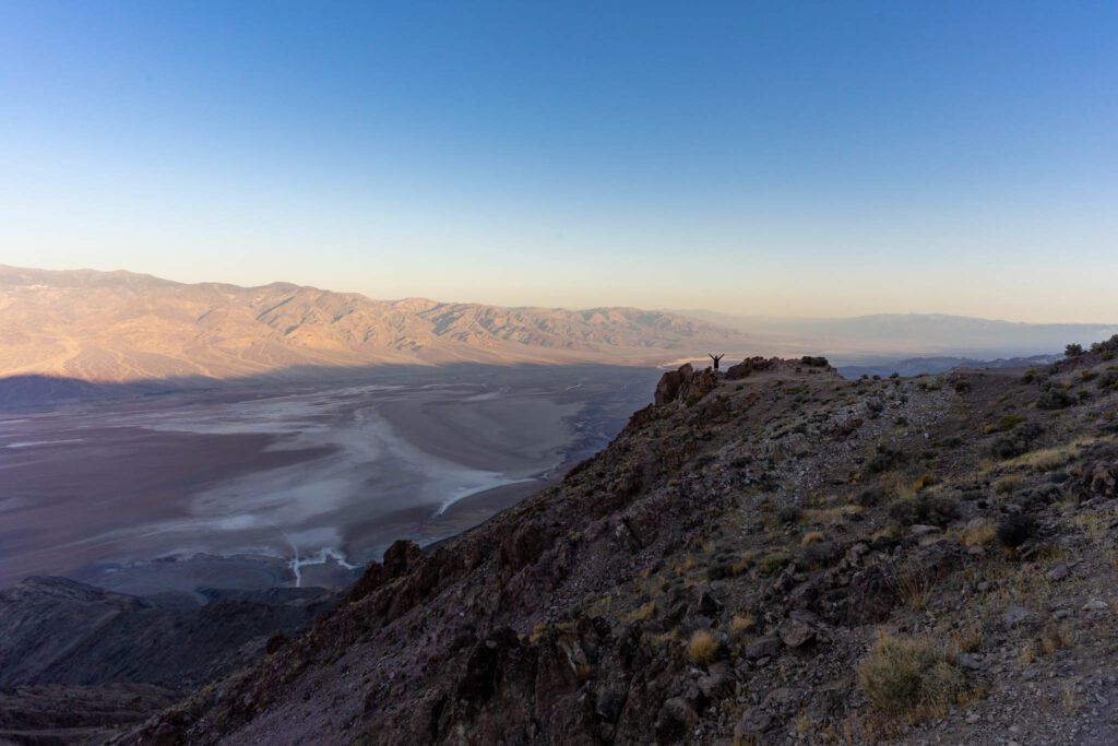
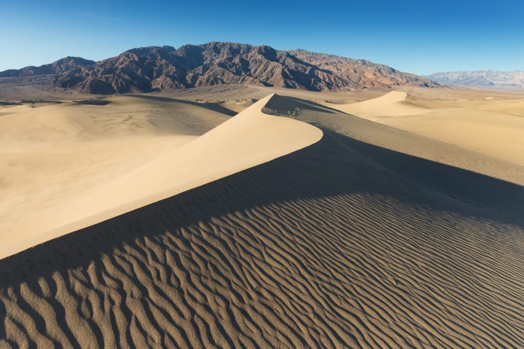
Death Valley National Park
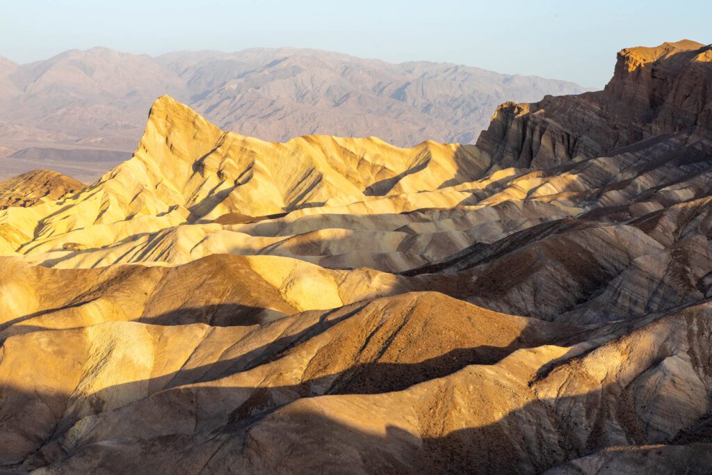
Death Valley (AKA the hottest place on earth) is one of the best national parks to visit in the winter and early spring – before the weather gets too hot! This Mojave Desert park has sand dunes, desert canyons, salt flats, and incredible views.
Go For: The sweeping desert vistas.
When to Visit: Unsurprisingly, Death Valley gets unbearably hot, with temperatures often hitting 120 degrees in the summer. The best (and safest) time to visit is in the winter and early spring, when the weather is milder but still warm.
Getting There: From the northwest, you’ll follow the 99 south and turn left on the 5, continuing until you turn left on the 14. Turn left on the 395, right on Searles Station, left on Trona Road, right on the 178, continue on Trona Wildrose Road, then turn left on Panamint Valley Road. Turn right on the 190, following it into the park.
From the south, you’ll take the 5 north to the 14, continuing east until you turn left on the 395. You’ll turn right on Searles Station, left on Trona Road, right on the 178, continue on Trona Wildrose Road, then turn left on Panamint Valley Road. Turn right on the 190, following it into the park.
Park Highlights:
- Explore Badwater Basin, a large salt flat known for its polygonal salt formations.
- Do a short hike to Zabriskie Point (0.4 miles) to enjoy incredible views of the park from above.
- Hike through a canyon and make your way to Red Cathedral via the Golden Canyon Trail (2.9 miles).
- Take a hike through the sand dunes (and maybe do some sand boarding) on the Mesquite Flat Sand Dune Trail (2.8 miles).
Where to Stay: There are three hotels (the Inn at Death Valley is the best option) located within the park, as well as nine campgrounds. Furnace Creek Campground is the only option that takes reservations (October through April), and is conveniently located in the middle of the park. Outside of the park, lodging choices aren’t super abundant, but you’ll have the most luck in the town of Beatty, NV. You’ll find hotels and rental homes in this area.
More Information:
- How to Plan the Perfect Death Valley Itinerary
- The 10 Best Hikes in Death Valley National Park
- Current Conditions (NPS)
- Hiking (NPS)
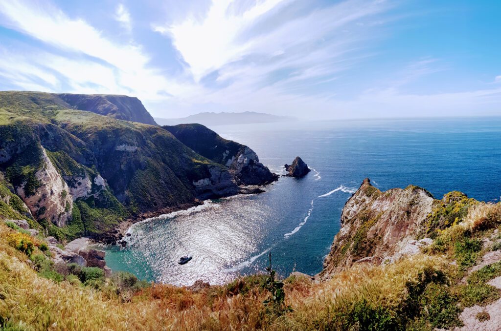
Channel Islands National Park
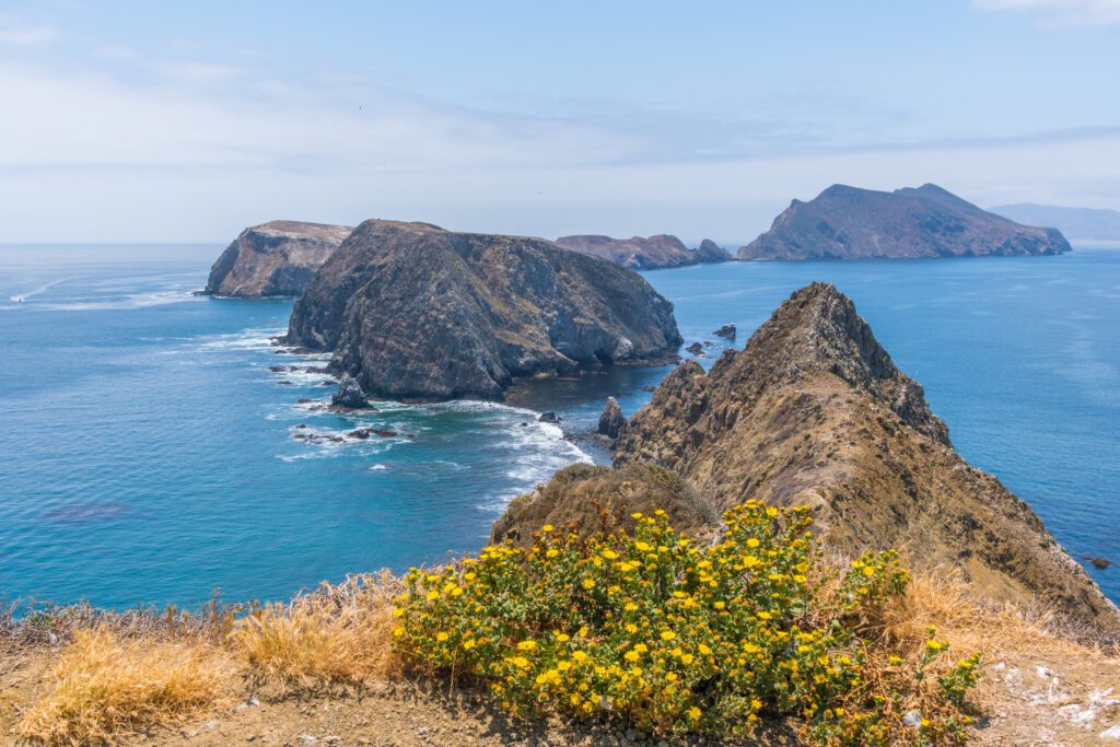
The relative remoteness of this national park makes it not as popular as some others – which means it’s a treat for those who decide to make the trek! This national park (consisting of five islands) is the place to go for people who love to be on and near the water, with plenty of opportunities for kayaking, snorkeling, exploring sea caves, and hiking along the coast.
Go For: The sea caves and coastal hikes.
When to Visit: The park is open year-round, but for those planning on kayaking and snorkeling, the best time to visit is in the mid/late summer and early fall, when the weather is warmer and the seas are calmer.
Getting There: The most common and cost-effective way to get to the islands is via boat with the company Island Packers Cruises, which services all islands. Channel Islands Aviation also provides flights to Santa Rosa and Santa Miguel Islands. Keep in mind that transportation is not available once on the islands! They can be explored by foot, kayak, or private boat.
Park Highlights:
- Explore the sea caves and the coast of Santa Cruz Island via a kayaking tour through Santa Barbara Adventure Company.
- See the amazing sea life by snorkeling. Santa Barbara Adventure Company provides snorkeling tours for those who want a guided experience.
- Hike some of the most popular trails on the island(s) you choose to visit, including Potato Harbor Trail (Santa Cruz Island), East Anacapa Island Trail (Anacapa Island), Pelican Bay Trail (Santa Cruz Island), and Lobo Canyon Trail (Santa Rosa Island).
Where to Stay: Each island has its own campground, and reservations are required (either via phone or online). Santa Cruz is the most visited (and most easily accessible) island, and its Scorpion Canyon Campground has 31 sites available (the most of any island). If you’re only coming in for a day trip, consider staying at a hotel in Ventura or Oxnard, near the boat harbor you’ll be departing from.
More Information:
- Camping (NPS)
- Island Transportation (NPS)
- Current Conditions (NPS)
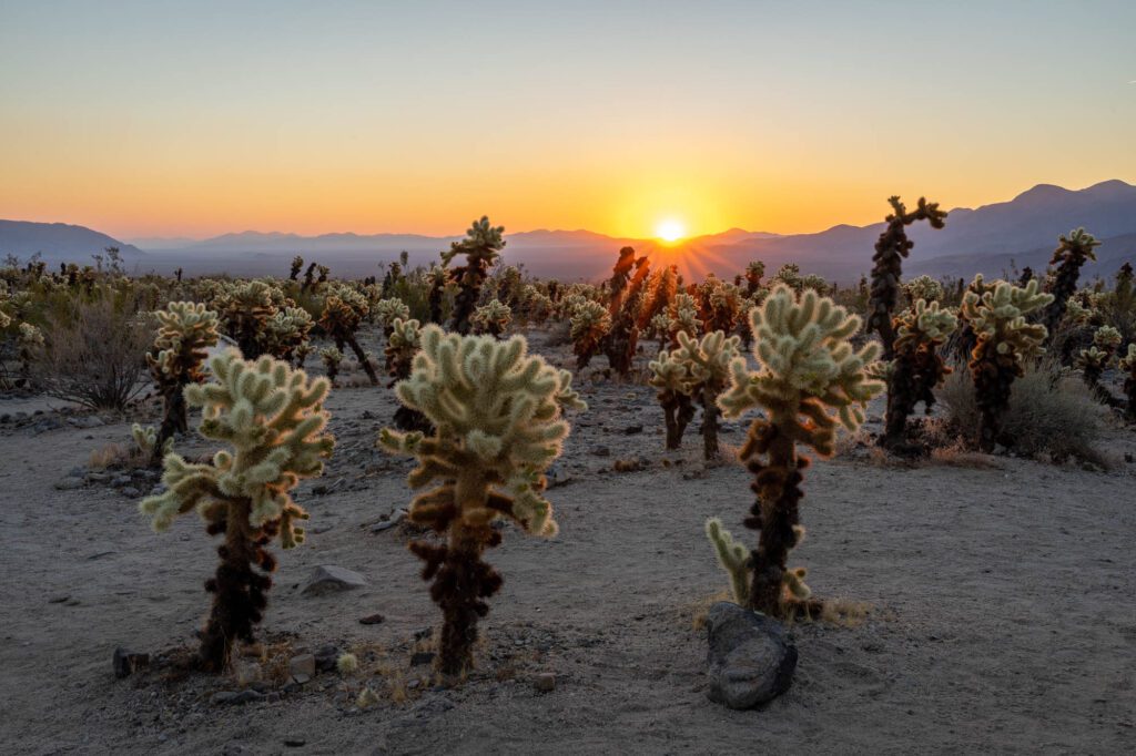
Joshua Tree National Park
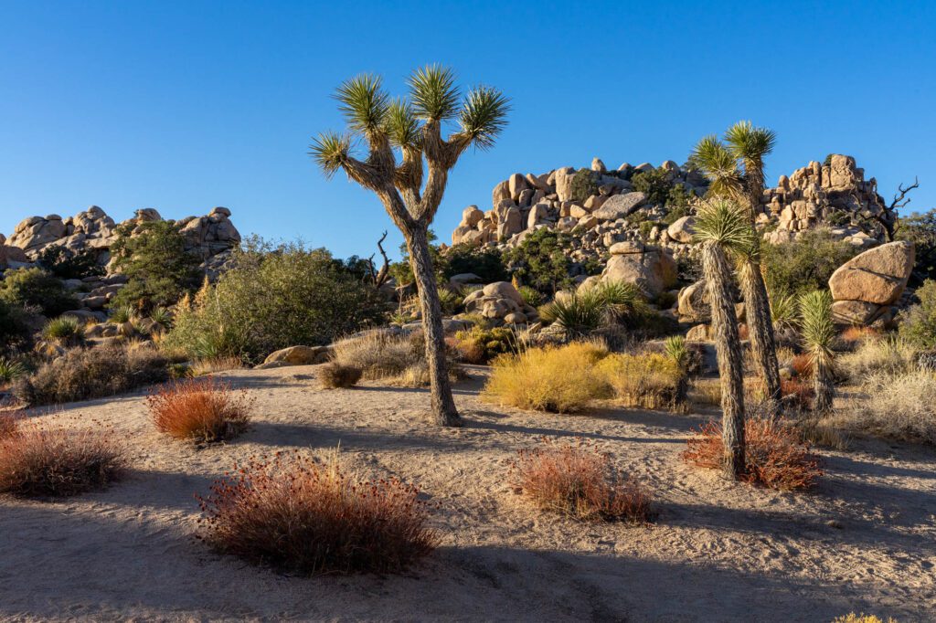
Joshua Tree National Park is a favorite for southern California locals. The famous Joshua trees and incredible rock formations create a uniquely beautiful desert landscape that can be enjoyed by hikers, campers, and visitors in general!
Go For: The Joshua trees and huge rock formations.
When to Visit: It’s best to visit Joshua Tree in the winter and early/mid spring, as the summer and fall get very hot. It can get very cold in the winter time at night.
Getting There: From the north/west, connect to the 10 east, following until you can exit on the 62. Follow it until you can turn right on Park Boulevard in the town of Joshua Tree, and continue to the park entrance. From the east, connect to the 10 west, and exit at Cottonwood Springs Road, following it into the park.
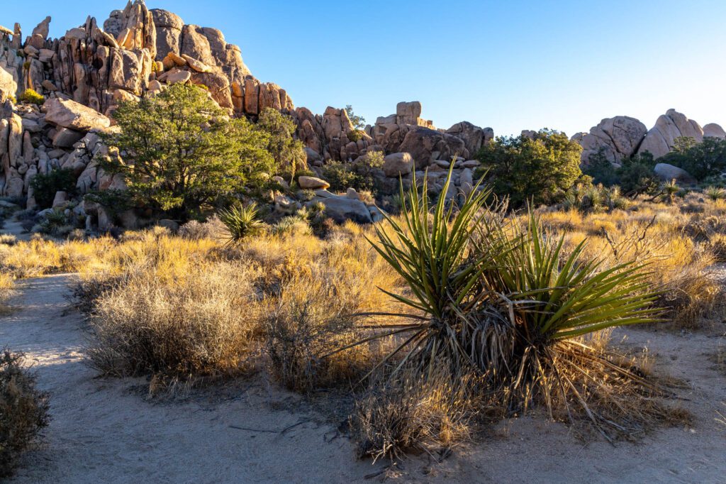
Park Highlights:
- Hike around Jumbo Rocks Campground (less than a mile) and spend some time climbing up some of the boulders (no equipment required – they’re easy to scale!).
- Take in the views from above the park by hiking up Ryan Mountain Trail (3 miles).
- Check out iconic rock formations and Joshua trees by hiking Arch Rock Nature Trail (1.2 miles), Split Rock Loop (1.9 miles), and Hidden Valley Nature Trail (1 mile).
- Enjoy the sunrise or sunset at Cholla Cactus Garden. The cactuses glow in the early and late day sun.
Where to Stay: In the park, there are eight campgrounds, five of which require reservations. Jumbo Rocks Campground (reservations required) is a visitor-favorite, because the campsites sit between huge, scenic rock formations. It’s also located right between many of the most popular hikes and sights in the park. Outside of the park, the town of Joshua Tree is one of the best places to stay. It’s located right by a park entrance, and there is an abundance of hotel and rental home options.
More Information: