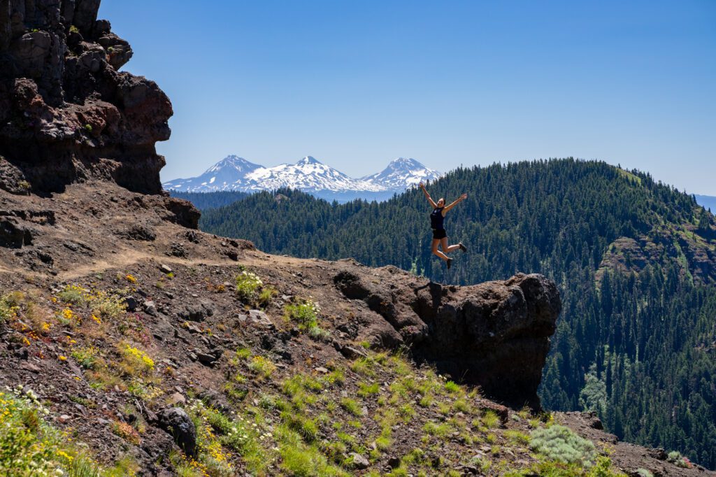
Hiking in Oregon: A Complete Guide for First Timers
Looking for a detailed guide to the best hikes in Oregon? You’re in the right place! In this guide to hiking in Oregon, we’re going to cover our favorite hikes in the state – all of which we have personally done and loved – along with all the logistics you’ll need to know like parking permits, dog-friendly hiking trails in Oregon, and more.
Why are we the right people to write this guide, you ask? Well, mostly because we live in Portland and spend as much time outside as possible (even during the dreary winter months – the best time for waterfalls and mossy forests!).
We love living in Portland because it puts many of the incredible hikes on this list within a few hours of our front door. From towering waterfalls to steep rocky ascents to peaks and viewpoints, Oregon has it all.
We’ve spent months and months living in a converted Honda Odyssey exploring the state, and we spent the better part of that time on various trails around Oregon.
In this guide, we’re going to give you our favorite hikes in Oregon based on our own personal experience exploring Oregon.
In this guide to our picks for best trails in Oregon, here’s what we’re going to cover:
- A few important logistics to keep in mind as you’re planning, like the different passes you might need and seasonal considerations to know before you go.
- Our favorite hikes in the state, including all the relevant details and a trail description with things to know (and links to deeper guides for some trails).
- A handy map of the trailheads for the hikes in this guide to help you visualize how it all fits together.
Throughout the guide, we’ll share our favorite hikes, viewpoints, waterfalls, and more based on our trips to help you plan your Oregon hiking adventures.
Sound good to you? Let’s get into it.
P.S. We’re certain that there are plenty of other great hikes that should be on this list, we just haven’t gotten around to them just yet! If you have hikes that you love that aren’t on this list, we’d like to hear them so we can add them to our list for the future!


Disclaimer: Some of the links in this post, like hotel and vacation rental links, are affiliate links, meaning at no additional cost to you we make a little bit of money if you click through and book. That being said, we would absolutely never recommend something to you that we don’t stand behind 100%.
The 18 Best Hikes in Oregon: A Complete Guide (from Two Local Hikers)
Now, onwards (and probably upwards) to the reason you’ve read this far – the list of our favorite hikes in Oregon.
Like we mentioned above, we’ve personally done all the hikes in this section of the guide, which means we have some specific tips and pointers for some of them. Like which direction to hike in, or how to get a parking spot.
If you have any questions, have a hike that you love and think should be on our list, or notice something that has changed, please drop us a comment below or shoot us an email!
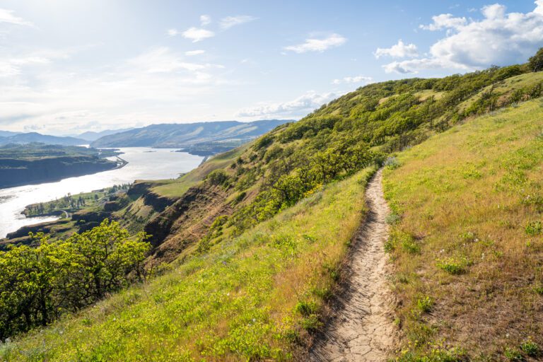
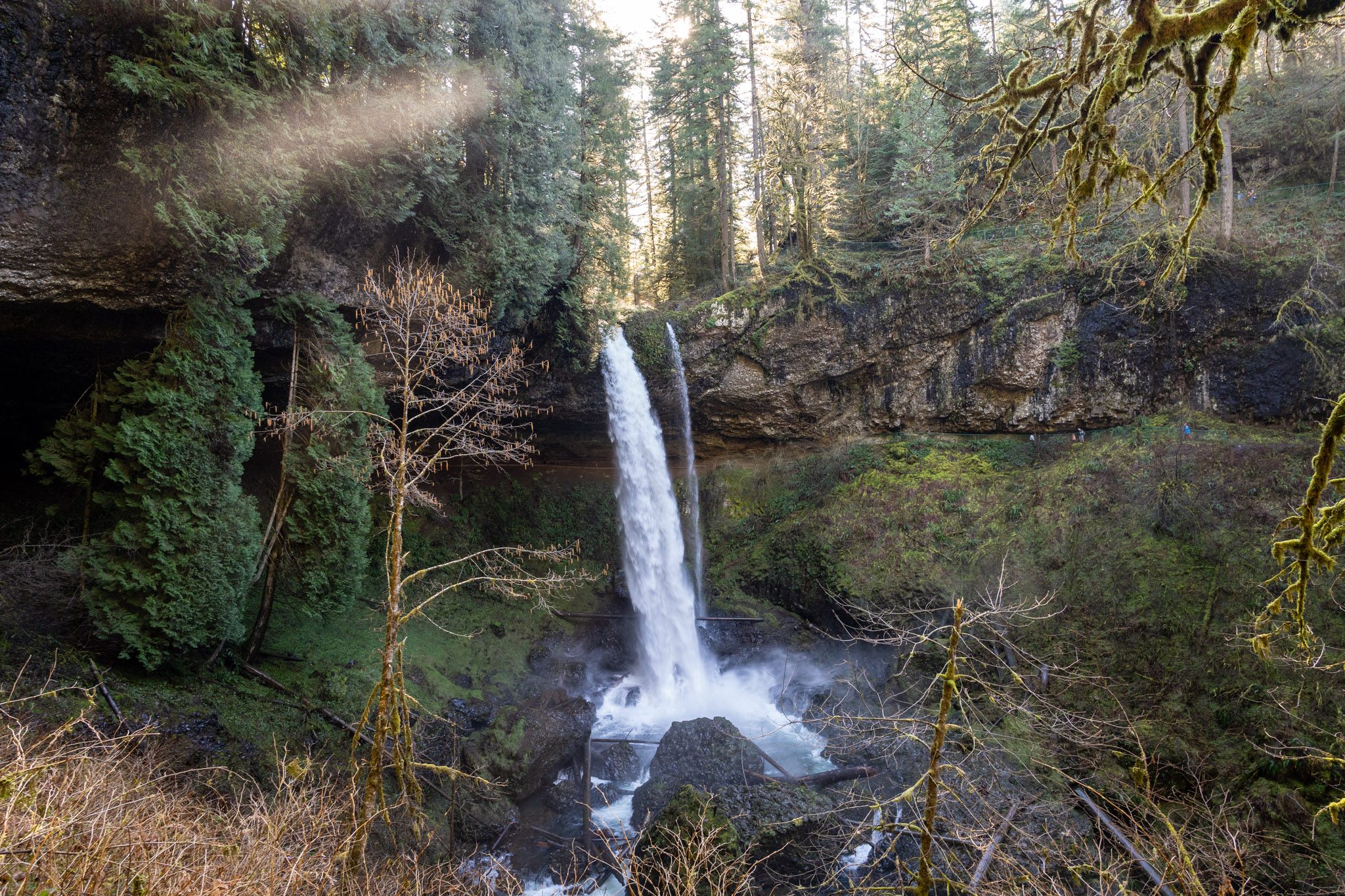
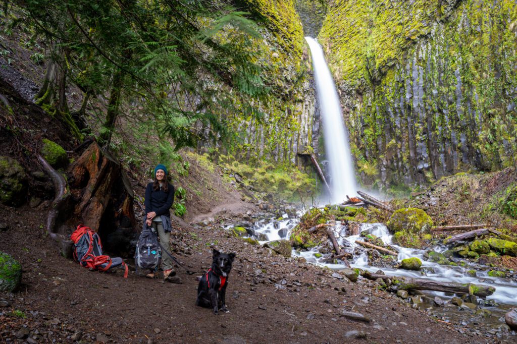
The Trail of Ten Falls (Silver Falls State Park)
- Length: 9 miles
- Elevation Gain: 1,400 ft.
- Trail Type: Loop
- Difficulty: Easy / Moderate
- Dog Friendly? No dogs allowed.
- Parking Pass: Oregon State Parks Pass
- Trailhead Location
If you’re looking for a waterfall hike in Oregon, a state known for its amazing waterfalls, this is the place to go. Silver Falls State Park is about an hour and a half south of Portland, near Salem.
The Trail of Ten Falls does a big loop, passing – you guessed it! – ten different waterfalls along the way. There’s no point in this hike where you’ll find significant elevation gain, so it’s a pretty easy hike overall. Don’t let the mileage scare you off.
Since it’s a loop, there are a couple of different places you can pick up the hike, but the best is going to be the South Falls Trailhead, where there’s a big parking lot.
Which, by the way, was completely full when we were there on a weekend morning in the summertime. So you’ll want to get there early to get a spot.
Do it clockwise, starting from South Falls and heading downhill to Lower North Falls, where the trail starts a gradual uphill climb, ending at Upper North Falls. From there, it’s a mostly flat walk back to the parking lot.
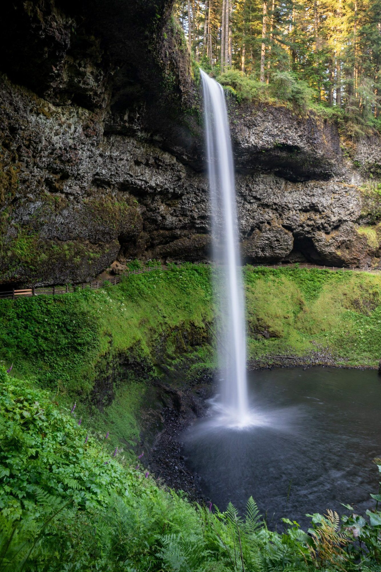
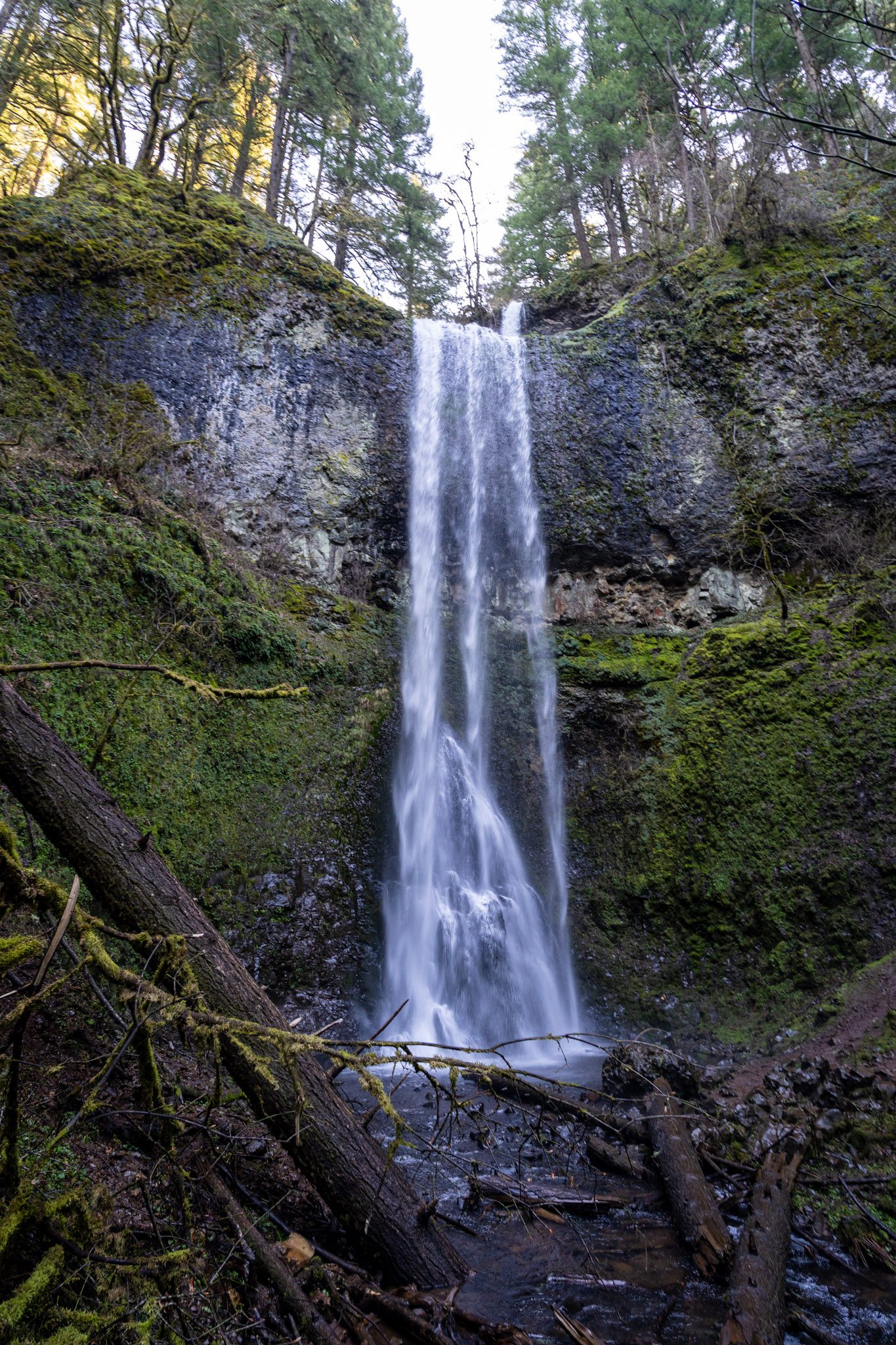
South Falls, standing at 177 feet, is the most impressive of them all in our opinion. It tumbles over the lip of a big bowl, which means you can actually walk behind the falls for a different – wetter – point of view.
North Falls (and Upper North Falls) and Double Falls are the other waterfalls that stood out to us.
Read More: Hiking the Spectacular Trail of Ten Falls in Silver Falls State Park (Helpful Trail Guide)
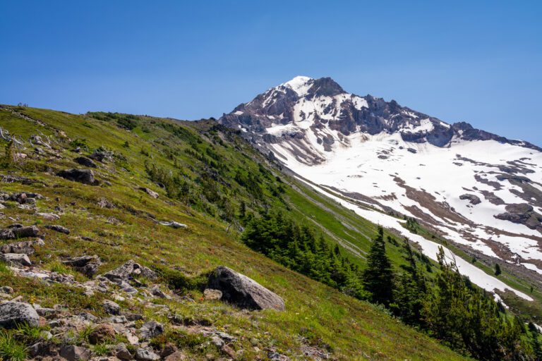
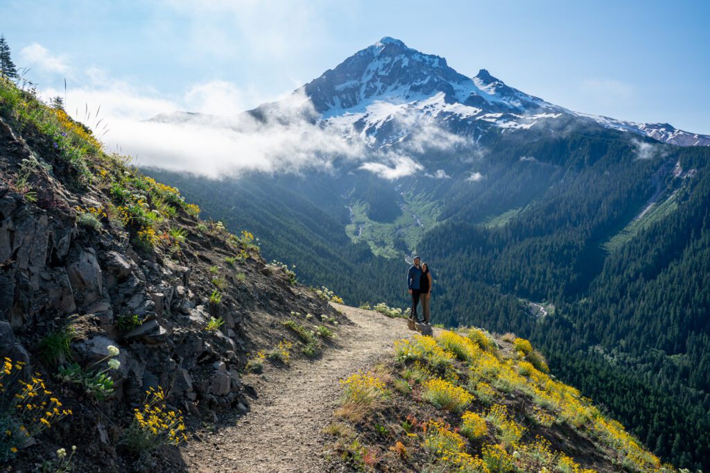
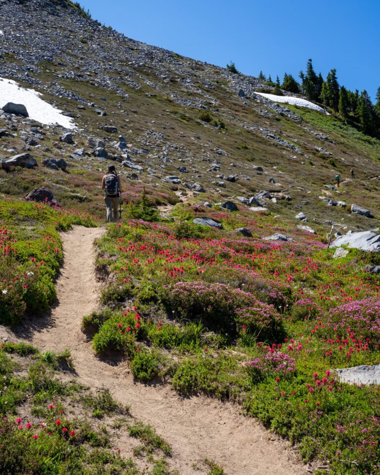
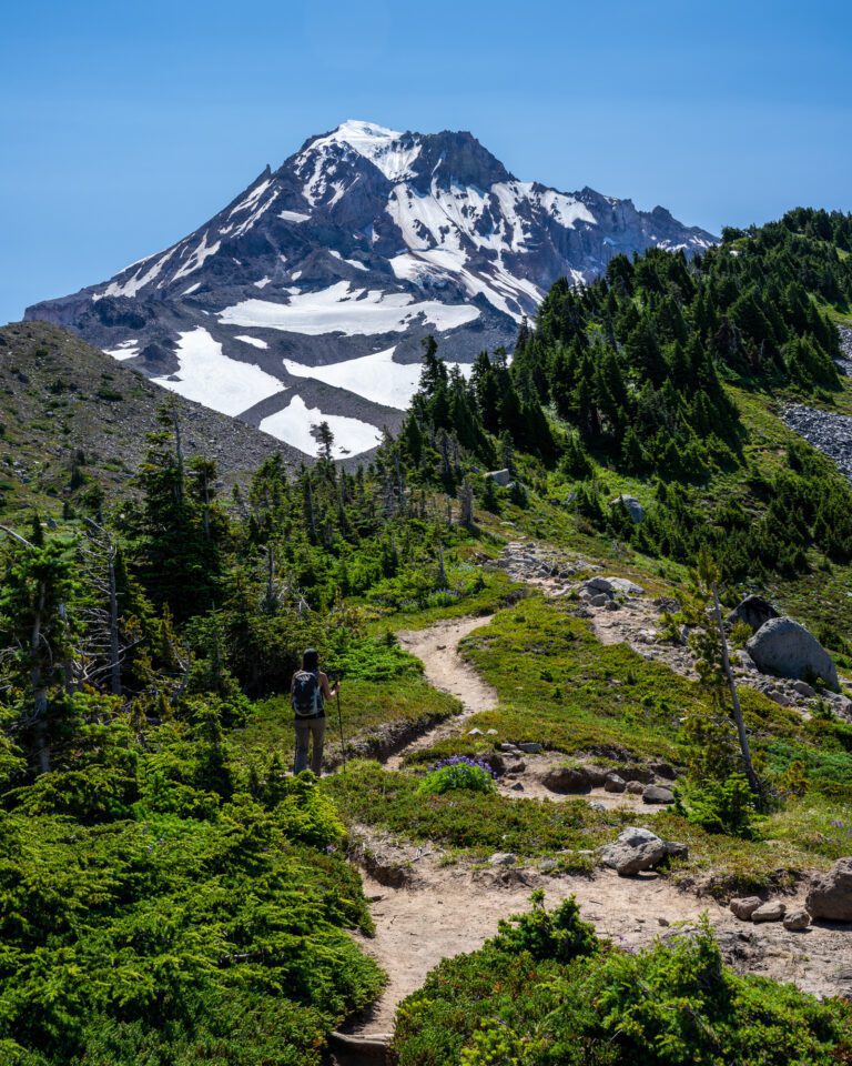
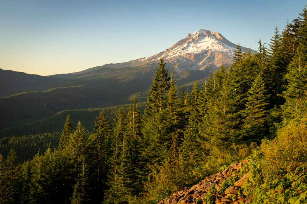
McNeil Point (Mount Hood National Forest)
- Length: 11 miles
- Elevation Gain: 2,700 ft.
- Trail Type: Lollipop
- Difficulty: (Very) Hard
- Dog Friendly? Yes, on a leash.
- Parking Pass: Northwest Forest Pass
- Trailhead Location
This might be our top pick for the single best hike in Oregon, but there are so many amazing hikes to choose from that it’s hard to choose just one!
The views of Mount Hood from this trail are nothing short of spectacular, but you’re going to have to work hard to earn them. When we hiked this trail, we were on our Oregon road trip, which had us hiking 7-10 miles almost every single day. We were in the best shape of our lives.
This trail kicked our butts and had us walking funny for several days afterwards. It’s a strenuous hike. Don’t underestimate it.
That being said, we’d do it again in a heartbeat. Especially when the wildflowers in the meadows at the top are in full bloom.
The trail is a lollipop – you’ll climb up to a junction where you start a mini loop near the top. The views come fast and furious from beginning to end, starting with our favorite view of Mount Hood from Bald Mountain about a mile into the hike.
The trail climbs somewhat gradually (but for a long, long time) up to a junction – going right takes you up a trail that is more of a scramble than a hike, and going left takes you on a longer meander through meadows of wildflowers with views of Mount St. Helens and Mount Adams to the north on a clear day.
We’d go up the scramble (definitely don’t go down that way) and down the meander, which will have you facing the great views and avoiding trying to scramble down the mountain.
At the top, there’s an old stone structure that was built by the Civilian Conservation Corps during the depression, the same group that built basically all of the infrastructure in places like Zion National Park. It’s a nice refuge from the wind, which is sure to be howling.
Bring plenty of food and water on this hike. It’s our favorite of the many amazing hikes at Mount Hood.
There’s a shorter, significantly easier version of this trail that starts lower, climbs up forested switchbacks bursting with rhododendrons in the spring, and ends at the best view of Hood at Bald Mountain.
We’ve done it both ways, and think McNeil Point is more spectacular, but less accessible because of its length and difficulty.
Read More: Hiking the Spectacular McNeil Point Trail at Mount Hood (Helpful Trail Guide)
The Iron Mountain / Cone Peak Trail (Willamette National Forest)
- Length: 6.1 miles
- Elevation Gain: 1,800 ft.
- Trail Type: Loop
- Difficulty: Moderate
- Dog Friendly? Yes, on leash.
- Parking Pass: Northwest Forest Pass
- Trailhead Location
This one is a wildcard. It was very much a “well we’re driving by, let’s check it out” that turned into the most spectacular show of wildflowers that I think we’ve ever seen.
This hike is best in the late spring / early summer, when the landscape is covered in all sorts of different colors – reds, yellows, purples, whites, and more.
There are a couple of ways to do this hike. Most people should begin at the trailhead and tackle it clockwise, starting with the climb to Iron Mountain, where there’s a 360-degree view of the surrounding Cascade Mountain Range with a helpful guide to the different peaks nearby.
From there, descend down to Cone Peak, which is more of a hill if you ask us, and descend the switchbacks back to the trailhead.
Doing it this way means getting the majority of the climbing out of the way early on, and gradually descending through the forested switchbacks at the end.
Did we mention the wildflowers? Cone Peak was blanketed in yellow flowers, and the switchbacks up to Iron Mountain were bursting with reds, yellows, and purples. Truly amazing, and we almost drove right past it and skipped it.
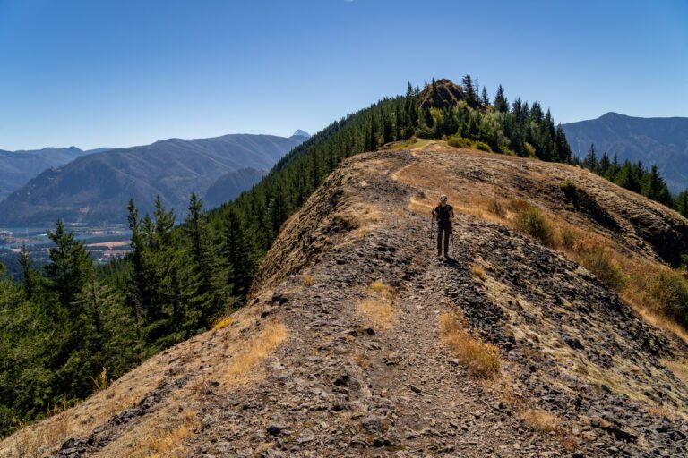
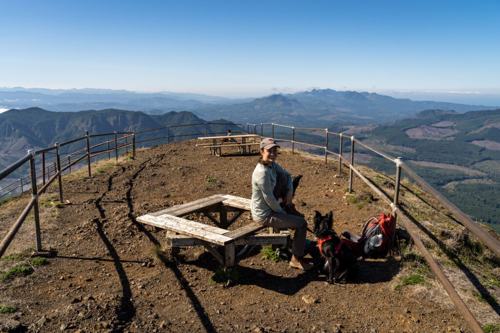
Tom, Dick, and Harry Mountain (Mount Hood National Forest)
- Length: 9 miles
- Elevation Gain: 1,700 ft.
- Trail Type: Out and Back
- Difficulty: Moderate / Hard
- Dog Friendly? Yes, on a leash.
- Parking Pass: Northwest Forest Pass
- Trailhead Location
This trail shares a trailhead with the very popular Mirror Lake Trail right off of US-26, which means it’s almost always full despite being a pretty large parking lot.
Mirror Lake is a little meh – I’ve never seen more mosquitoes in my life – but the climb to the ridge above it is much, much better.
The hike up to Mirror Lake is fairly easy – you’ll see all sorts of families with small kids doing it – and you cross a few footbridges along the way. The first portion of the path is paved and ADA accessible.
The climbing really starts to ramp up as you leave the lake and make your way up to the ridge, which sits 1,000 feet above it.
From Mirror Lake, it’s a 2.5 mile hike up to the ridge, and then you can hike out across the ridge for an ever changing view of Mount Hood across the valley. On a clear day, you’ll also be able to see some of the other peaks in the Cascade Range, like Mount Adams and Jefferson.
At the top, there are some sections of trail that take you across boulder fields, which can be tough to navigate. Make sure you’re prepared with sturdy footwear and a map (we use AllTrails for this).
Read More: How to Hike to Tom, Dick, and Harry Mountain
The Ramona Falls Trail (Mount Hood National Forest)

- Length: 7.1 miles
- Elevation Gain: 1,000 ft.
- Trail Type: Lollipop
- Difficulty: Easy / Moderate
- Dog Friendly? Yes, on a leash.
- Parking Pass: Northwest Forest Pass
- Trailhead Location
Another spectacular waterfall hike in Oregon. This one is in Mount Hood National Forest on the southwestern side of the mountain, and the hiking distance is enough to make it so that the majority of people don’t make it out here.
However, we think you definitely should because the trail isn’t particularly hard, and it’s gorgeous once you cross the Sandy River.
Speaking of crossing the river, that’s the most difficult part of this hike. When we were there, the river was roaring and there was basically nowhere to cross. We ended up tightroping it over a downed log, which seemed to be the only way to get across.
We later learned that there is usually a seasonal bridge installed here by the Forest Service, but they no longer put it up as of 2021 (please let us know if this changes!). That means you’re left to your own devices when it comes to crossing the river. Which can be dangerous when the river is high.
The trail is a lollipop, starting with a relatively boring walk out to the river, which is just over a mile. Once you find your way across the river, there’s a fork in the trail – left takes you on the Pacific Crest Trail, right takes you along the river.
Both directions get you to Ramona Falls, and we don’t really have a strong perspective which way is better or more scenic. We went clockwise, but I’m not sure it really matters.
Ramona Falls is a towering waterfall that seems nearly as wide as it is tall (and it’s 120 feet tall). Individual torrents of water cascade over the mossy green rocks, ending in a small creek at the foot of the falls.
Complete the loop, cross the river, and head back to your car once you’ve picked your jaw up off the trail.
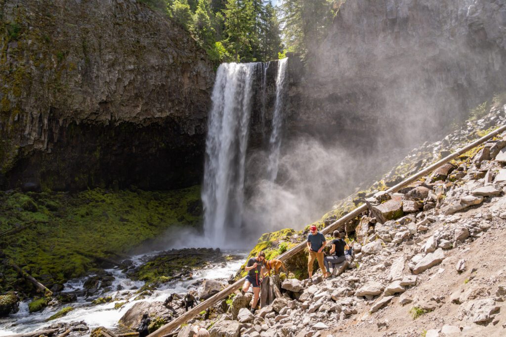
Tamanawas Falls (Mount Hood National Forest)
- Length: 3.4 miles
- Elevation Gain: 600 feet
- Trail Type: Out and Back
- Difficulty: Easy / Moderate
- Dog Friendly: Yes, on a leash.
- Parking Pass: Northwest Forest Pass
- Trailhead Location
We finally checked this hike off of our list on our latest trip up to Mount Hood and Hood River with some friends, and it blew our expectations out of the water.
Oregon is a state known for its epic waterfalls, and Tamanawas Falls should be at the top of every hiker’s list, especially if you’re looking for a good hike near Hood River.
The Tamanawas Falls trail starts right off of Highway 26 on the eastern side of Mount Hood. It’s a small parking lot, and there are signs prohibiting parking all up and down the highway on either side.
There were tons of cars parked on the side of the road anyway, and I’m sure they all thought “they can’t give us ALL tickets, right? Safety in numbers!”
Well, we saw rangers handing out tickets as we left. Get there early, and only park in the lot.
The trail starts by crossing the river over a wooden footbridge, and then heads into the forest. It’s a pretty easy hike all the way through, and it’s a lovely trail that follows a creek through the woods with the sound of the water accompanying you on your journey up the falls.
There’s one stretch of the hike that’s tough, and it’s right before you get to the falls. It’s a steep, rocky, slippery section that lasts less than a quarter mile. Alysha actually slipped and fell on the way down, resulting in a big purple bruise.
It’s tough, but it’s not the kind of thing that should prevent most people from doing the hike. Wear shoes or boots with good traction, take it slow, and you’ll likely be fine.
The waterfall at the end is well worth the relatively low effort it takes to reach it. The water tumbles off of a rocky shelf, falling 110 feet down into Cold Spring Creek below. The mist coming off the waterfall is a nice respite from the heat in the summer, though it makes taking pictures of the falls a little tricky.
Read More: How to Hike the Tamanawas Falls Trail (A Helpful Trail Guide)
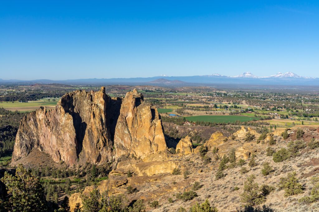
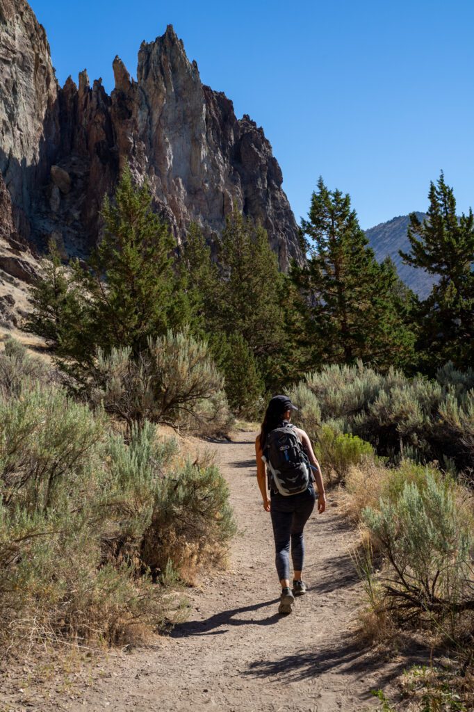
The Misery Ridge Trail (Smith Rock State Park)
- Length: 6 miles
- Elevation Gain: 1,700 ft.
- Trail Type: Loop
- Difficulty: Moderate / Hard
- Dog Friendly? Yes, on a leash.
- Parking Pass: Oregon State Parks Pass
- Trailhead Location
This hike is appropriately named, we think. The first section of trail, which climbs straight up a gully, ascending 700 feet in about a third of a mile, is no joke. We were huffing and puffing the entire way through.
The hike as a whole is a fantastic reminder that once you cross the Cascades into central and eastern Oregon, the landscape changes. Drastically. This is the high desert, and the rock formations in Smith Rock State Park are unlike anything you’d see in Western Oregon.
It feels more like Utah or Arizona than anything you think of when you think about the Pacific Northwest.
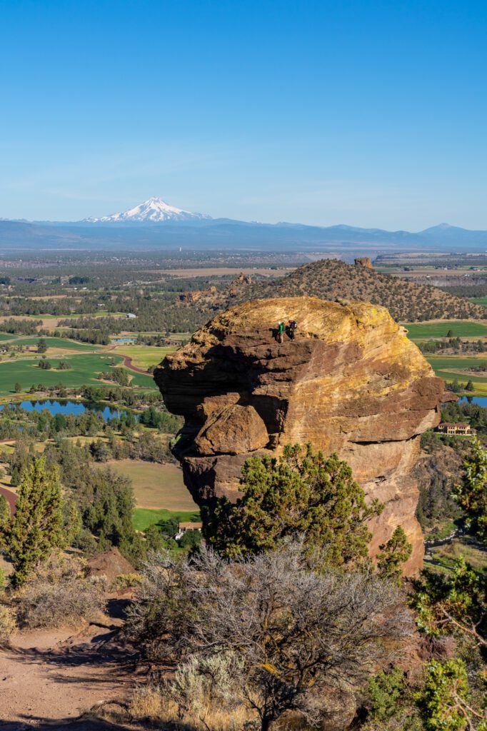
Once you’re up on the ridge, though, the views are spectacular. The trail continues up and over the ridge, where you’ll come face to face with Monkey Face, a huge destination for rock climbers in Oregon.
Monkey Face is also aptly named. It looks exactly like the profile of a monkey from a certain angle. You’re likely to see climbers scaling the rock face. That’s a no from me, Bob.
From the top, you’ll then immediately descend a steep set of switchbacks to get back down to the river.
There are two different ways you could tackle this trail, and the junction happens once you’ve gone up the climb, over to Monkey Face, and descended back down to the river level. You’ll come to a junction – left takes you back along the flat river trail, right takes you on a gentler climb along the Summit Trail, which is the one we’d recommend.
I’ve done it both ways, and the Summit Trail was full of great views, especially once you get up onto the ridge. I did it with about 20 hungover bachelor party attendees, so you’ll probably be fine. Get an early start to beat the heat – especially in the summer – bring plenty of water and snacks, and watch out for rattlesnakes.
We saw one on our last time out there, and it was the first (and only) rattlesnake I’ve ever seen in person! Be aware of where you place your hands and feet, and give them plenty of space.
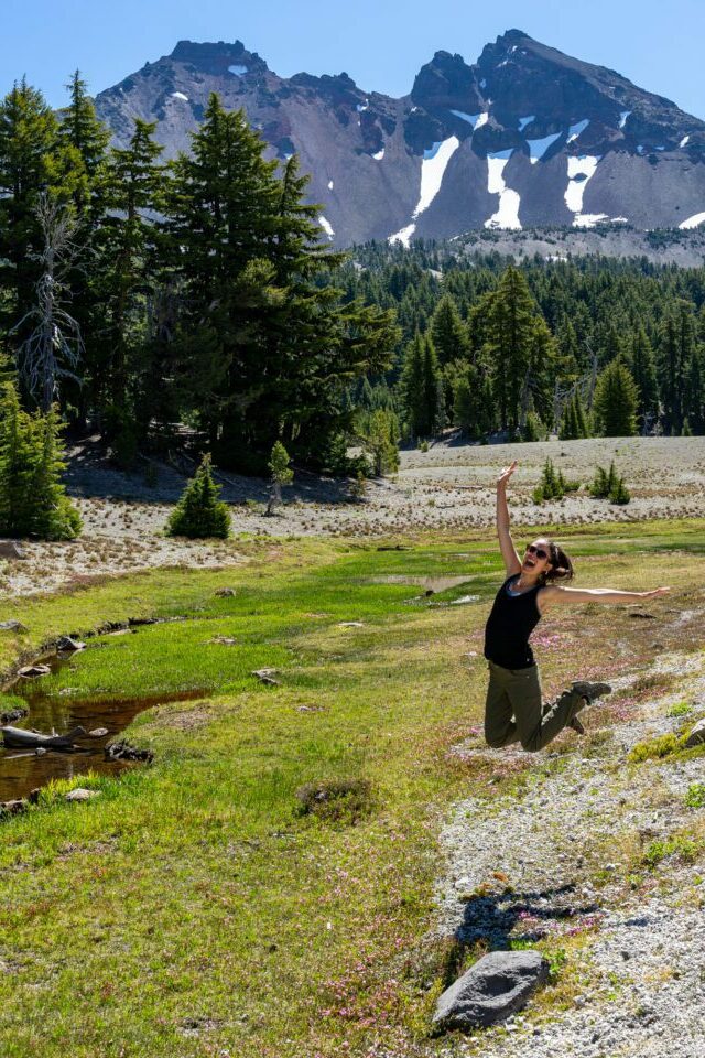
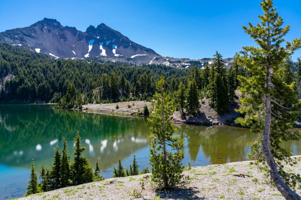
The Green Lakes Trail (Deschutes National Forest)
- Length: 9.1 miles
- Elevation Gain: 1,200 ft.
- Trail Type: Out and Back
- Difficulty: Moderate
- Dog Friendly? Yes, on a leash.
- Parking Pass: Northwest Forest Pass
- Trailhead Location
This hike is one of our favorite hikes near Bend, and while nine miles seems like a lot, it’s not a particularly difficult hike.
If meandering through lush meadows alongside a rushing river (okay, technically it’s a creek) before emerging into a jaw-dropping valley nestled between two rocky peaks – the South Sister and Broken Top – sounds like a good time, this is the trail for you.
Plus, it offers the best bang for your buck in Oregon in terms of the beauty to effort ratio.
Despite the distance, Alysha and I agreed that this hike is actually pretty easy. There aren’t any really steep portions. It’s just a gentle climb all the way through. Don’t let the 9 mile length scare you off!
Basically, the entire trail follows Fall Creek, which means you’ll be treated to the sounds of a babbling brook the entire way through. And waterfalls. Lots of waterfalls.
The sound of the creek only stops when you emerge into the meadows at the end of the hike, where you’ll find yourself in between three pristine alpine lakes at the base of two of Oregon’s most spectacular peaks.
We arrived at 7:30 am on a weekday in July, and it was already fairly busy. I’d recommend either a weekday hike, or getting to the trailhead – which is a 45 minute drive from Bend – no later than 8:00 am on a weekend.
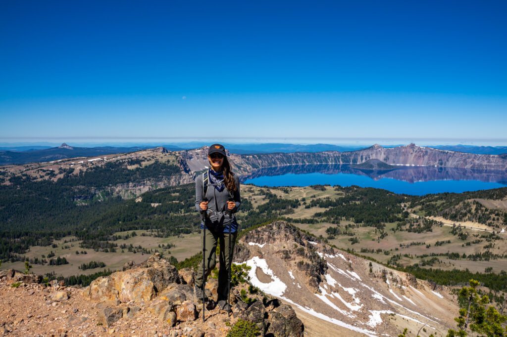
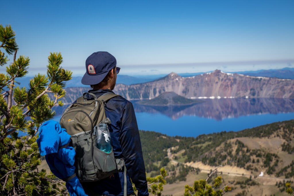
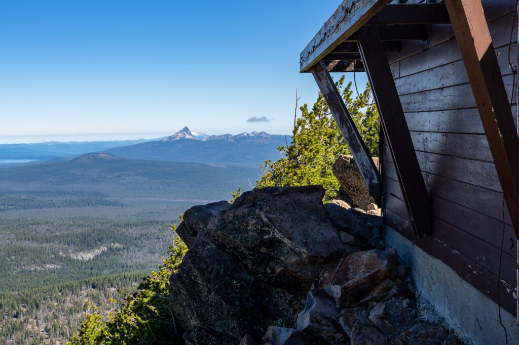
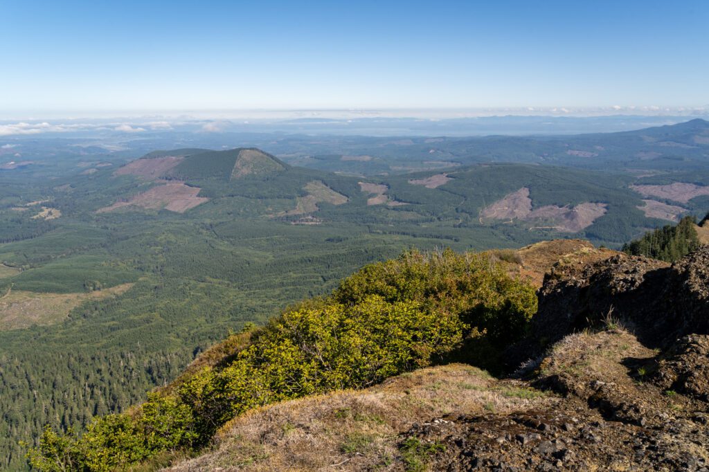
The Mount Scott Trail (Crater Lake National Park)
- Length: 4.2 miles
- Elevation Gain: 1,300 ft.
- Trail Type: Out and Back
- Difficulty: Moderate
- Dog Friendly? No dogs allowed.
- Parking Pass: America the Beautiful
- Trailhead Location
This hike takes you up to the highest point in Crater Lake National Park, on the eastern side of the lake, to an old fire lookout with great views over the lake and surrounding landscape, including Mt. Thielsen and Mt. McLoughlin in the distance.
It’s a pretty steady climb from the trailhead up to the lookout. There are some switchbacks along the way, and the view of the deep blue water of Crater Lake seems to get better and better as you ascend. Just wait until you get to the top.
Note: The road on the eastern side of Crater Lake is closed in the winter, which means that you can’t drive to the trailhead. You can still access the trailhead in the late spring / early summer by parking here, right outside the gate, and hiking to the trailhead.
It adds a couple of miles in each direction, but it’s along a paved road. We were there on the day the road opened for the season, but we actually did the hike the day before, when the road was still closed.
Check road conditions here.
The Cleetwood Cove Trail (Crater Lake National Park)

- Length: 2.0 miles
- Elevation Gain: 600 ft.
- Trail Type: Out and Back
- Difficulty: Moderate
- Dog Friendly? No dogs allowed.
- Parking Pass: America the Beautiful Pass
- Trailhead Location
While we’re on Crater Lake, let’s talk about the trail that gets you to the lowest accessible point in Crater Lake National Park. The Cleetwood Cove trail takes you from the rim road right down to the water level. And, yes, you can jump in.
This is the only spot in the park (that we know of – let us know if that has changed or if we’re mistaken!) where you can get to the water level.
To get there, though, you climb straight down an unforgiving set of switchbacks. Great, right? Downhill isn’t too bad!
Except what goes down must come back up, and it’s a tough climb on the way back up. And Crater Lake sits at around 6,000 feet of elevation, which makes it that much harder.
There’s really not much else to say. It’s a straightforward hike down to the water, where it’s worth admiring the crystal clear (and freezing cold) water before making the ascent back to your car. Take your time and bring plenty of water.
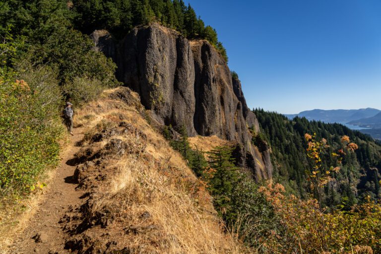
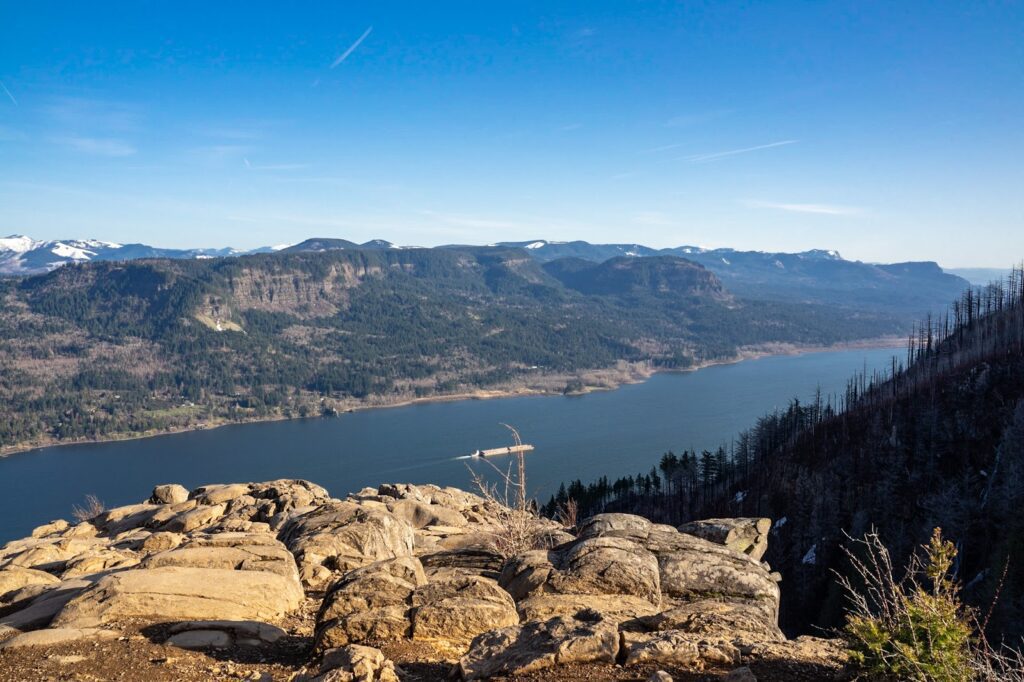
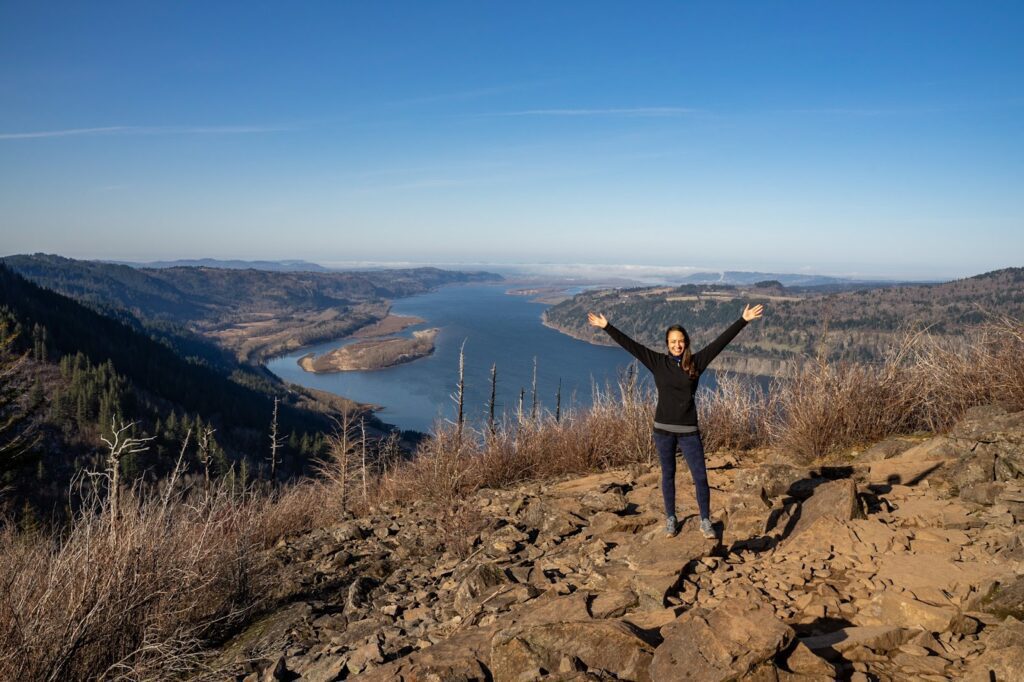
The Angel’s Rest Trail (Columbia River Gorge)
- Length: 4.5 miles
- Elevation Gain: 1,500 ft.
- Trail Type: Out and Back
- Difficulty: Moderate
- Dog Friendly? Yes, on a leash.
- Parking Pass: Northwest Forest Pass
- Trailhead Location
Of all the amazing hikes in the Columbia River Gorge, Angel’s Rest is one of our favorites on the Oregon side.
The views of the Gorge from the top are great, but you’re going to work for them with a steady, moderate climb from beginning to end. The good news? It’s not a particularly long hike. The not-so-good news? It’s a thigh-burner.
You start from the trailhead just past Bridal Veil Falls in the Gorge along I-84, which is a tiny parking lot and will be full by 9:00 am on most weekends between spring and fall.
For the first mile and a half, you’ll alternate between a series of switchbacks interspersed with steadier climbs. with a few points where you have a preview of the view of the Gorge you get from the top.
At 1.5 miles in, you’ll hit some tight, steeper switchbacks, which signals the beginning of the final ascent. There are some rocky sections near the top of the hike where you’ll essentially be walking on a tiny boulder field, but nothing too crazy.
From the top, you’ll have a view of the entire gorge, all the way to the west towards Portland and the Pacific, and then out to the east, over to the Washington side and towards Hood River. It’s a great view, and we think you’ll agree that it’s worth the effort to get there.
On the way there or back, make sure to drive along the historic Columbia River Highway – which runs parallel to I-84 – for some of the best views in the Gorge.
Stop at the Portland Women’s Forum State Scenic Viewpoint (here on Google Maps), the Vista House (here on Google Maps), and the short but beautiful Latourell Falls Trail.
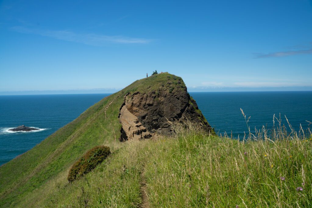
God’s Thumb (Oregon Coast)
- Length: 4.3 miles
- Elevation Gain: 1,100 ft.
- Trail Type: Out and Back
- Difficulty: Easy / Moderate
- Dog Friendly? Yes, on a leash.
- Parking Pass: Northwest Forest Pass
- Trailhead Location
First of all, this hike gets very, very muddy when it rains. Or when it has rained recently, which is pretty much year round. We saw a couple of people doing it in their brand new white Nikes, which was a shame. Those shoes will never be the same.
Read the recent trail reports before you go so that you know whether or not to expect a mud bath!
This hike is in Lincoln City, and takes you out to the coast where there’s a little peninsula jutting out into the Pacific Ocean that has been named God’s Thumb.
The hike out to God’s Thumb is nice – it’s a forested trail that passes by the Knoll first, a stunning viewpoint out over the Oregon Coast, and then continues until you emerge onto the bluff over the ocean.
The final ascent to the top is steep and skinny, but it should be doable for most people. Stick to the well-worn trail, and take it slow. It will be windy at the top, so bring a windbreaker.
Note: When it’s muddy, the trail up to the thumb at the end gets washed out, and it’s very slippery. We’d avoid climbing up to the top if it’s super muddy.
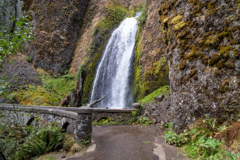
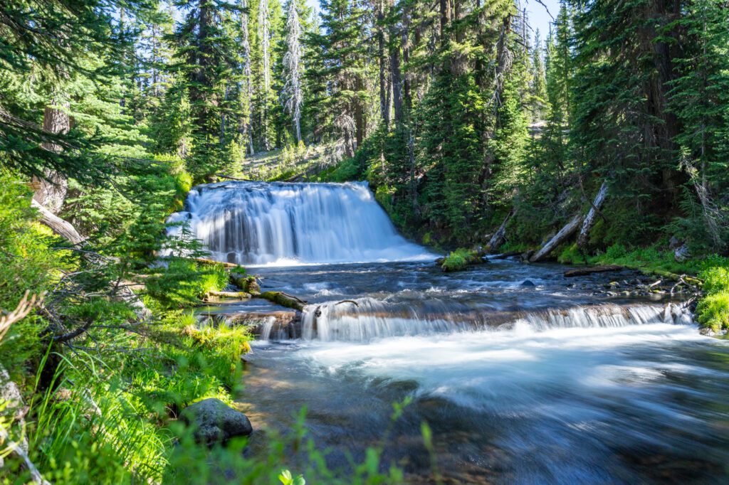
Dry Creek Falls (Columbia River Gorge)
- Length: 4.4 miles
- Elevation Gain: 900 ft.
- Trail Type: Out and Back
- Difficulty: Easy / Moderate
- Dog Friendly? Yes, on a leash.
- Parking Pass: Northwest Forest Pass
- Trailhead Location (or here)
In an area full of great waterfalls – like the more famous Multnomah Falls, and the less famous but equally beautiful Latourell Falls – we decided to pick just one for this list.
Multnomah is amazing, of course, but the reason we excluded it is twofold. One, it’s just too busy. Two, the best part of the hike (we think) is at the parking lot where you get that picture-perfect view of Multnomah.
We landed on Dry Creek Falls, which is a short and relatively easy hike through the woods along the Pacific Crest Trail to a 74 foot waterfall. We did it on a cold February morning, where the ground was a little bit hard and the wind was brisk, and we were two of six people on the trail.
The hike starts from the Bridge of the Gods trailhead in Cascade Locks, which is tiny, and meanders through a forest that was affected by the Eagle Creek fire in 2017, but is still beautiful.
It’s a gentle uphill grade almost all the way to the falls, except for a short steep ascent right before the falls that you’ll barely notice because you’re so excited to get your first glimpse of the waterfall itself.
Dry Creek Falls tumbles off of a ridge 74 feet above the ground, and it’s an impressive sight in the winter when the falls are stronger thanks to all the precipitation in the Pacific Northwest.
Read More: How to Hike to Dry Creek Falls along the PCT
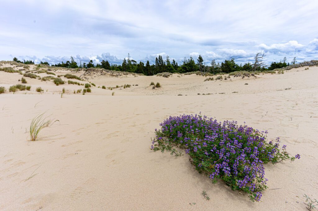
The John Dellenback Trail (The Oregon Dunes)
- Length: 5.5 miles
- Elevation Gain: 308 ft.
- Trail Type: Out and Back
- Difficulty: Easy
- Dog Friendly? Yes, on a leash.
- Parking Pass: Northwest Forest Pass
- Trailhead Location
This unique hike on the Oregon Coast spans multiple different ecosystems, and ends at a wide sandy beach on the Pacific Ocean. The best part about that beach is that it’s only accessible by hiking in, which means it’s basically deserted.
The hike starts with an amble along a well-established sandy trail until you emerge onto a mini bluff, with the sprawling Oregon Dunes in front of you.
The Dunes are amazing, and we were in awe of the patches of wildflowers and forest that were somehow alive and well in the middle of this sandy landscape.
Hiking on the dunes is a bit of a nightmare. It’s slow-going, hard, and your shoes will be full of sand by the end of the hike.
High-top hiking boots will be your friend here, otherwise you’ll be in for a day of sandy shoes.
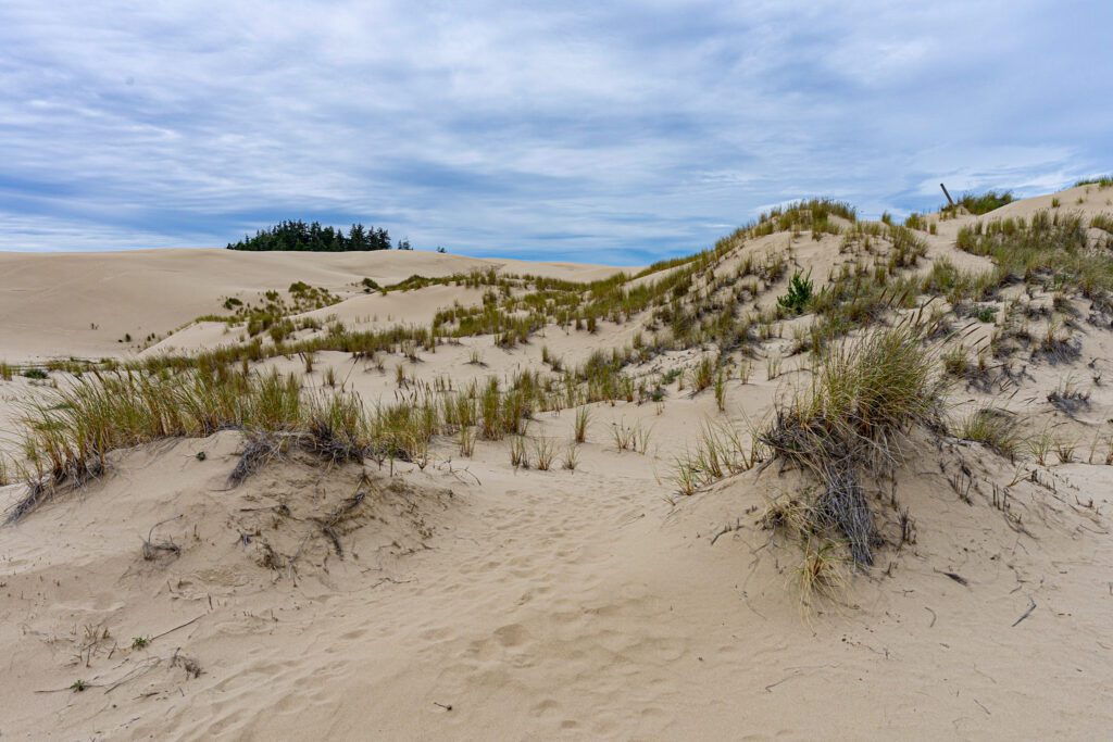
The trail traverses the dunes and when you reach the other side, you briefly enter a forested but still somehow sandy stretch that emerges onto a beautiful beach.
Note: You’ll need a map here, because the trail markers in the dunes are hard to find, at best. We use AllTrails (specifically AllTrails Pro, which gives you the ability to download a trail map and show your own location).
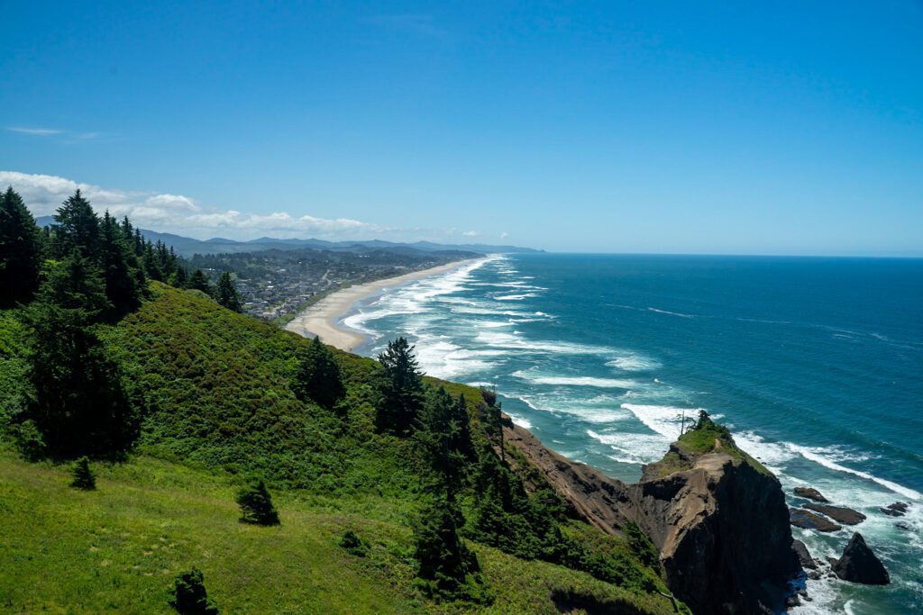
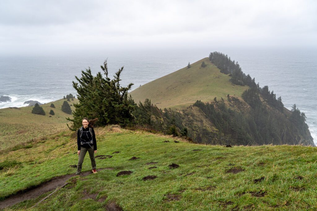
Neahkahnie Mountain (Oregon Coast)

- Length: 4.0 miles
- Elevation Gain: 1,200 ft.
- Trail Type: Out and back
- Difficulty: Moderate
- Dog Friendly? Yes, on a leash.
- Parking Pass: Oregon State Parks Pass
- Trailhead: Elk Flats Parking Lot
This is probably our favorite of the hikes in Oswald West State Park. And it’s really just because of the view at the top, which includes an incredible vista of Manzanita Beach stretching endlessly south.
There are multiple ways to do this hike, and the most popular version is to start from the northern trailhead, which is right off of 101. This is also the longer, harder version of the hike.
The alternate option is to go from the south trailhead, which is a half mile off of 101 up a narrow forest road, which cuts the distance to 2.6 miles and 850 feet of elevation gain.
Both parking lots are relatively small (maybe 20 or so cars each?), and will fill up on warm weekend mornings.
The hike itself – no matter which way you do it – is really nothing all that interesting or special. It’s essentially straight up, and straight down, and you’re in the forest the entire time. Expect switchbacks and more switchbacks.
Then, you’ll emerge from the sitka spruce forest and there’s that amazing view waiting for you. But that’s really the only time you get any kind of view.
As we were relaxing at the top, we saw a bald eagle circling (you can even see it in the picture of Alysha!), which was a nice touch.
Important note: At the time of writing (winter 2022), the north trail is closed due to some serious downed trees. Hike from the south trailhead instead, which is still open and is actually an easier hike.
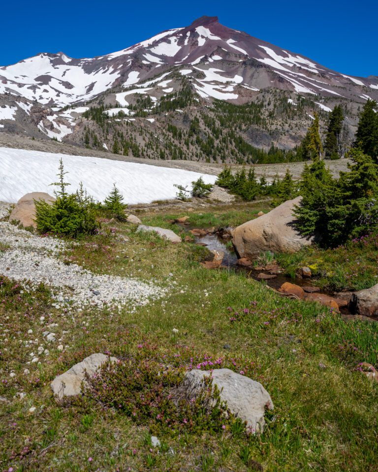
The Timberline Lodge to Zigzag Canyon Trail (Mount Hood National Forest)

- Length: 4.7 miles
- Elevation Gain: 880 ft.
- Trail Type: Out and Back
- Difficulty: Moderate
- Dog Friendly? Yes, on a leash.
- Parking Pass: Northwest Forest Pass
- Trailhead Location
If you’re looking for a nice, relatively easy hike near Mount Hood with great mountain views and spectacular scenery, this is a great option.
It follows the Pacific Crest Trail (also part of the Timberline Trail, which circumnavigates Hood) from Timberline Lodge – which is well worth a visit either before or after your hike – and cuts across the ski runs around the lodge.
From there, it’s a steady descent down to Zigzag Canyon. Be prepared to climb back uphill on the way home.
The views at the endpoint of the hike are pretty stunning. You’ll find yourself looking up a rugged rocky canyon that, well, zig zags its way up to the snowy peak of Mount Hood.
In the early summer when we did this hike, there were a plethora of wildflowers along the trail, including some beautiful flowers right at the viewpoint.
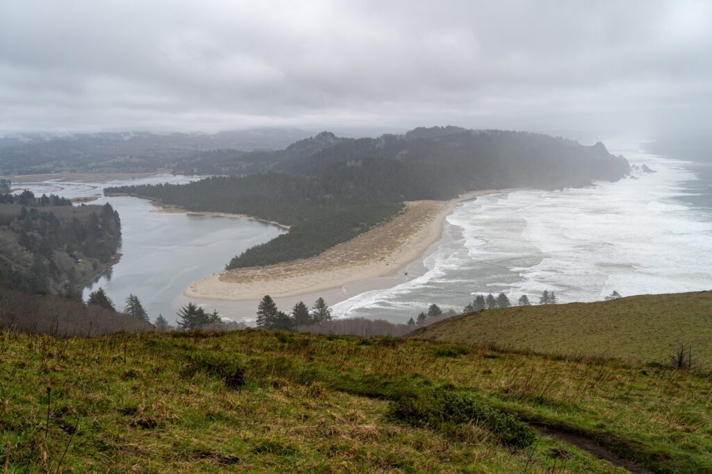
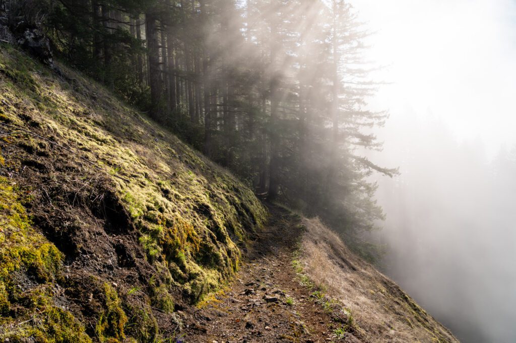
Cascade Head (Oregon Coast)
- Length: 4.2 miles
- Elevation Gain: 1,100 ft.
- Trail Type: Out and Back
- Difficulty: Moderate
- Dog Friendly? No dogs allowed.
- Parking Pass: Northwest Forest Pass
- Trailhead Location
Until our latest trip, this hike had been closed every time we looked at it. Not so this time! Only problem? It was the dead of winter. So the weather wasn’t great.
There are a couple of ways to do this hike, and the easiest and most direct is to drive most of the way up to the upper trailhead, which results in a shorter, easier hike.
However, not only is that trailhead closed at the time of writing, but the hike from the bottom up is really, really nice and we’d recommend it. Which is why that’s the version we’re talking about here.
The parking lot for the trail is at the south trailhead, and from there the hike starts out along the road for a hot second before jumping onto a boardwalk and path that parallels the road, taking you into a dense ferny forest.
Then you’ll get dumped out back onto the road, which you’ll follow to the actual starting point for the hike, which is roughly here.
Heads up – this trail is known for the Tule elk that call the area home. We saw a big herd of them in the field on the right as you hike on the road to the starting point of the actual trail. Be on the lookout!
The trail starts with a steep set of stairs in various conditions, so watch your footing. From the beginning of this hike, you’re walking through a dense sitka spruce forest, with ferns along the forest floor. It’s magical, and it’s one of the aspects of hiking in the Pacific Northwest that we love, especially along the coast.
The trail continues to climb steadily through the forest, and at approximately 1.2 miles into the hike, you’ll emerge from the forest onto Cascade Head, where you’ll have magnificent views to the south and west (at least on a clear day).
It was very, very blustery as soon as we exited the forest, so be prepared for some wind.
The trail snakes around the point and then starts a more intense climb up the hill to an even better viewpoint, which involves 500 feet of elevation gain in a touch more than a quarter of a mile.
This is where the lower and upper trail meet – the upper trail approaches this viewpoint from above, which makes it a much easier (but less interesting) hike.
This trail is operated and maintained by the Nature Conservancy, and DOGS ARE NOT ALLOWED.
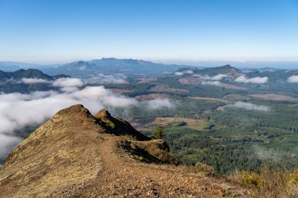
The Saddle Mountain Trail
- Length: 4.8 miles
- Elevation Gain: 1,800 ft.
- Season: Year Round (unless it has been really cold)
- Trail Type: Out and Back
- Difficulty: Moderate / Difficult
- Dog Friendly? Yes, on a leash (see note on mesh along trail below)
- Pass Required: None (even though it’s in an Oregon State Natural Area)
- Trailhead Location
The Saddle Mountain Trail had been on our list for YEARS by the time we had finally gotten to hike it. It came onto our radar for the first time when we did our very first Oregon Coast road trip during the summer of 2020, which is the time that cemented Oregon as our future long term home.
Since then, we’ve driven the Oregon Coast many, many times on our way down to Alysha’s mom’s house in Northern California (the coastal route, though slower, is SO MUCH more pleasant than I-5), and every single time we’ve checked in on Saddle Mountain only to find that it’s still closed for trail repairs.
It was closed for two years (maybe more?), and as soon as we heard that it was re-opening in early September of 2023, we marked the date on our calendars.
Two days after it opened, we left our house in Portland in the early morning, and 90 minutes later arrived at the Saddle Mountain Trailhead.
Only to find a thick bank of coastal fog waiting for us at the beginning of a trail known for its spectacular, never ending views in all directions.
“Well, we came all the way out here, might as well head up and see if it clears” we told ourselves as we started up the trail.
By the time we made it to the top, we had gotten above the fog (which was still sitting in some of the surrounding valleys) and could see clear to the Pacific Ocean to the west, the mouth of the Columbia River to the north, and over to Mount Rainier (barely!), Mount St. Helens and Mount Adams, and Mount Hood to the east.
The difficulty category for this hike is a little tough for us to put our finger on, because the first half and the second half are almost completely different hikes.
The first half (ish, it’s really more like two thirds) is pretty firmly in the moderate category. Then, you hit a viewpoint facing south, and the trail almost immediately turns more difficult, with a series of rocky climbs on the way up to the saddle.
From the saddle, the hike is downright difficult. The last quarter mile or so is steep, rocky (though there is a metal mesh to help with traction), and makes you earn the excellent views from the top.
Careful on the way down, too. A fellow hiker slipped and fell, and both of us slipped at one point (though we stayed on our feet).
The trailhead is along Highway 26 on the way out towards Cannon Beach and Seaside just before you get out to the coast, so it would make an excellent beginning to a day trip from Portland out to the coast.
One note for dog owners: The top half of the trail – from the saddle to the peak, mostly – is covered in what is essentially chain link fence laid down along the trail. We took our dog Lupine up with us not realizing this, and while she didn’t have any injuries, she definitely was not a fan of it, and I can see it being troublesome for dogs, especially bigger ones.
Our Favorite Oregon Hikes, Mapped
Here’s a map of all of the Oregon hikes (really, the trailheads) mentioned in this guide so that you can visualize where these hikes are.
Need-to-Know Tips for Hiking in Oregon
Here are a few things we think you should know before hitting the trails in Oregon.
Oregonians LOVE Hiking
Especially in the summer. Trails will be packed, especially the popular ones (let’s be honest, almost every single trail below is in the “popular” category).
Get to the trailhead before 9:00 am (8:00 am, if you can) to snag a parking spot and not have to worry about finding additional parking that may or may not be totally legal.
Most trails are Dog Friendly (BUT They Need to Be on a Leash)
Coming from California originally, where dogs aren’t allowed anywhere, this is a pleasant surprise.
We call out whether or not a hike is dog friendly in the mini trail guides above, but you should know that you definitely can’t take dogs on the trails in Crater Lake.
Be Prepared to Be Wet (and Muddy)
Especially between November and June. Waterproof hiking boots (or shoes) are basically an essential, as is a solid waterproof rain jacket.
Mud is also very common throughout the year, especially on the coast. Check trail reports before you go to see if it’s going to be muddy. Bring a pair of extra shoes to change into post-hike and thank me later if you’re journeying into the muck.
Leave No Trace
It should go without saying, but we are constantly flabbergasted at the amount of human waste we find on hiking trails all over the western United States.
Y’all, we gotta take care of the places we love exploring! If you carry it in, make sure to carry it out. And pick up after your dog!
Read about leave no trace principles here.
Passes and Permits for Hiking in Oregon
There are a couple of passes you’ll want to know about if you’re planning on tackling some of these Oregon hiking trails.
Oregon State Parks Pass ($30)
If you’re hiking in an Oregon State park, you’ll need to display this pass to park (or pay on arrival – it costs $5 a day).
Here’s a list of the places where it’s valid. Buy it online in advance here, or you can usually buy it on arrival.
Northwest Forest Pass ($30)
This covers all national forest land in Oregon and Washington – there’s a lot of it! Most of the hikes below require this pass. You can see where the Northwest Forest Pass is valid here.
Buy it online at REI, and it’s good for 12 months from the month you purchase it (so it’s better to purchase at the beginning of the month!).
Be warned that, while you technically can get a day use permit at trailheads where you put $5 cash into a little envelope and put the stub on your windshield, we had multiple experiences of the day-use permits being unavailable, which had us running around to various stores to try and get an annual pass.
If you have an America the Beautiful Pass, you do not need a Northwest Forest Pass.
The America the Beautiful Pass ($80)
This pass covers all federal recreation lands in the country – including national parks, national forests, and national monuments. You will need to either have this pass or pay a $30 entrance fee for Crater Lake National Park.
In general, it’s worth it if you’re planning on visiting three or more national parks in a year (which would cost you $90 without this pass). Buy it in advance online at REI, or get it on arrival at the toll both at a national park.
In each trail guide above, we covered which pass you need so that you can be prepared before you reach the trailhead and realize “oh no, we don’t have our pass and there’s no day passes available!”
We’ve been there, and it really puts a damper on the whole experience.